You are here: Home > Network List > RV - Regional Alberta Seismic Observatory for Earthquake Studies Network Stations List
> Station HILA High Level, AB > Earthquake Result Viewer
HILA High Level, AB - Earthquake Result Viewer
| Earthquake location: |
Peru-Brazil Border Region |
| Earthquake latitude/longitude: |
-11.0/-70.8 |
| Earthquake time(UTC): |
2018/08/24 (236) 09:04:06 GMT |
| Earthquake Depth: |
609 km |
| Earthquake Magnitude: |
7.1 Mww |
| Earthquake Catalog/Contributor: |
NEIC PDE/us |
|
| Network: |
RV Regional Alberta Seismic Observatory for Earthquake Studies Network |
| Station: |
HILA High Level, AB |
| Lat/Lon: |
58.56 N/117.02 W |
| Elevation: |
329 m |
|
| Distance: |
78.8 deg |
| Az: |
337.312 deg |
| Baz: |
133.751 deg |
| Ray Param: |
0.047473956 |
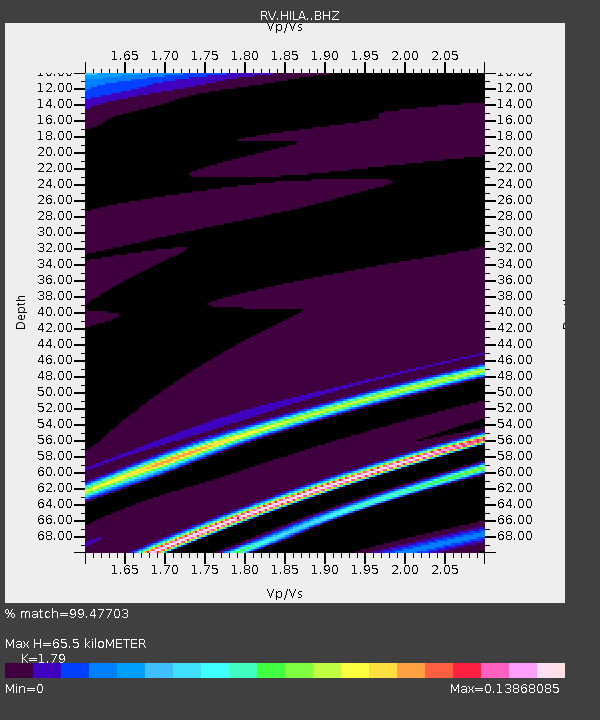
| Estimated Moho Depth: |
65.5 km |
| Estimated Crust Vp/Vs: |
1.79 |
| Assumed Crust Vp: |
6.498 km/s |
| Estimated Crust Vs: |
3.63 km/s |
| Estimated Crust Poisson's Ratio: |
0.27 |
|
| Radial Match: |
99.47703 % |
| Radial Bump: |
90 |
| Transverse Match: |
98.82078 % |
| Transverse Bump: |
159 |
| SOD ConfigId: |
13570011 |
| Insert Time: |
2019-04-30 23:54:29.999 +0000 |
| GWidth: |
2.5 |
| Max Bumps: |
400 |
| Tol: |
0.001 |
|

Signal To Noise
| Channel | StoN | STA | LTA |
| RV:HILA: :BHZ:20180824T09:14:36.725007Z | 1.5080472 | 0.0014637655 | 9.706364E-4 |
| RV:HILA: :BHN:20180824T09:14:36.725007Z | 1.405881 | 0.0017364884 | 0.0012351603 |
| RV:HILA: :BHE:20180824T09:14:36.725007Z | 1.4483606 | 0.0010009223 | 6.910726E-4 |
| Arrivals |
| Ps | 8.2 SECOND |
| PpPs | 27 SECOND |
| PsPs/PpSs | 36 SECOND |


