You are here: Home > Network List > RV - Regional Alberta Seismic Observatory for Earthquake Studies Network Stations List
> Station KIMIA Kimiwan Lookout Tower, AB > Earthquake Result Viewer
KIMIA Kimiwan Lookout Tower, AB - Earthquake Result Viewer
| Earthquake location: |
Peru-Brazil Border Region |
| Earthquake latitude/longitude: |
-11.0/-70.8 |
| Earthquake time(UTC): |
2018/08/24 (236) 09:04:06 GMT |
| Earthquake Depth: |
609 km |
| Earthquake Magnitude: |
7.1 Mww |
| Earthquake Catalog/Contributor: |
NEIC PDE/us |
|
| Network: |
RV Regional Alberta Seismic Observatory for Earthquake Studies Network |
| Station: |
KIMIA Kimiwan Lookout Tower, AB |
| Lat/Lon: |
55.99 N/116.61 W |
| Elevation: |
764 m |
|
| Distance: |
76.9 deg |
| Az: |
335.572 deg |
| Baz: |
133.731 deg |
| Ray Param: |
0.04874388 |
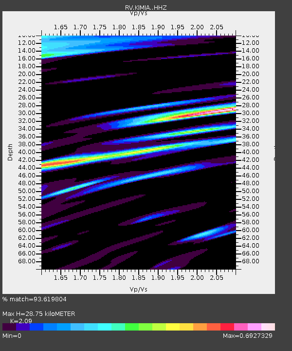
| Estimated Moho Depth: |
28.75 km |
| Estimated Crust Vp/Vs: |
2.09 |
| Assumed Crust Vp: |
6.426 km/s |
| Estimated Crust Vs: |
3.075 km/s |
| Estimated Crust Poisson's Ratio: |
0.35 |
|
| Radial Match: |
93.619804 % |
| Radial Bump: |
384 |
| Transverse Match: |
83.94397 % |
| Transverse Bump: |
400 |
| SOD ConfigId: |
13570011 |
| Insert Time: |
2019-04-30 23:54:34.810 +0000 |
| GWidth: |
2.5 |
| Max Bumps: |
400 |
| Tol: |
0.001 |
|

Signal To Noise
| Channel | StoN | STA | LTA |
| RV:KIMIA: :HHZ:20180824T09:14:26.360017Z | 127.844955 | 2.3165989E-5 | 1.8120377E-7 |
| RV:KIMIA: :HHN:20180824T09:14:26.360017Z | 15.938603 | 8.43959E-6 | 5.295062E-7 |
| RV:KIMIA: :HHE:20180824T09:14:26.360017Z | 27.606712 | 9.743758E-6 | 3.5294886E-7 |
| Arrivals |
| Ps | 5.0 SECOND |
| PpPs | 13 SECOND |
| PsPs/PpSs | 18 SECOND |


