You are here: Home > Network List > TA - USArray Transportable Network (new EarthScope stations) Stations List
> Station D25K Kavik River, AK, USA > Earthquake Result Viewer
D25K Kavik River, AK, USA - Earthquake Result Viewer
| Earthquake location: |
Peru-Brazil Border Region |
| Earthquake latitude/longitude: |
-11.0/-70.8 |
| Earthquake time(UTC): |
2018/08/24 (236) 09:04:06 GMT |
| Earthquake Depth: |
609 km |
| Earthquake Magnitude: |
7.1 Mww |
| Earthquake Catalog/Contributor: |
NEIC PDE/us |
|
| Network: |
TA USArray Transportable Network (new EarthScope stations) |
| Station: |
D25K Kavik River, AK, USA |
| Lat/Lon: |
69.32 N/146.38 W |
| Elevation: |
770 m |
|
| Distance: |
95.2 deg |
| Az: |
339.794 deg |
| Baz: |
107.32 deg |
| Ray Param: |
0.040195893 |
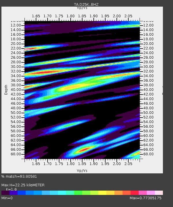
| Estimated Moho Depth: |
22.25 km |
| Estimated Crust Vp/Vs: |
1.60 |
| Assumed Crust Vp: |
6.378 km/s |
| Estimated Crust Vs: |
3.986 km/s |
| Estimated Crust Poisson's Ratio: |
0.18 |
|
| Radial Match: |
93.80581 % |
| Radial Bump: |
400 |
| Transverse Match: |
91.90454 % |
| Transverse Bump: |
400 |
| SOD ConfigId: |
13570011 |
| Insert Time: |
2019-04-30 23:54:59.814 +0000 |
| GWidth: |
2.5 |
| Max Bumps: |
400 |
| Tol: |
0.001 |
|
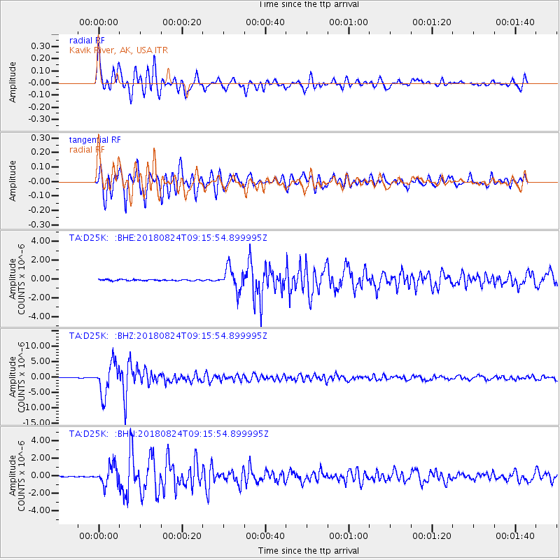
Signal To Noise
| Channel | StoN | STA | LTA |
| TA:D25K: :BHZ:20180824T09:15:54.899995Z | 74.7735 | 5.250009E-6 | 7.021217E-8 |
| TA:D25K: :BHN:20180824T09:15:54.899995Z | 23.098022 | 1.1088111E-6 | 4.800459E-8 |
| TA:D25K: :BHE:20180824T09:15:54.899995Z | 21.577618 | 1.2100795E-6 | 5.608031E-8 |
| Arrivals |
| Ps | 2.1 SECOND |
| PpPs | 8.9 SECOND |
| PsPs/PpSs | 11 SECOND |


