You are here: Home > Network List > TA - USArray Transportable Network (new EarthScope stations) Stations List
> Station H24K Noodor Dome, AK, USA > Earthquake Result Viewer
H24K Noodor Dome, AK, USA - Earthquake Result Viewer
| Earthquake location: |
Peru-Brazil Border Region |
| Earthquake latitude/longitude: |
-11.0/-70.8 |
| Earthquake time(UTC): |
2018/08/24 (236) 09:04:06 GMT |
| Earthquake Depth: |
609 km |
| Earthquake Magnitude: |
7.1 Mww |
| Earthquake Catalog/Contributor: |
NEIC PDE/us |
|
| Network: |
TA USArray Transportable Network (new EarthScope stations) |
| Station: |
H24K Noodor Dome, AK, USA |
| Lat/Lon: |
65.84 N/147.88 W |
| Elevation: |
814 m |
|
| Distance: |
94.8 deg |
| Az: |
336.262 deg |
| Baz: |
106.238 deg |
| Ray Param: |
0.040331542 |
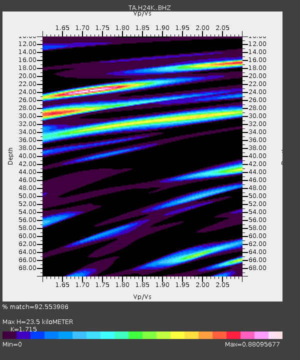
| Estimated Moho Depth: |
23.5 km |
| Estimated Crust Vp/Vs: |
1.72 |
| Assumed Crust Vp: |
6.566 km/s |
| Estimated Crust Vs: |
3.829 km/s |
| Estimated Crust Poisson's Ratio: |
0.24 |
|
| Radial Match: |
92.553986 % |
| Radial Bump: |
400 |
| Transverse Match: |
85.71668 % |
| Transverse Bump: |
400 |
| SOD ConfigId: |
13570011 |
| Insert Time: |
2019-04-30 23:55:19.588 +0000 |
| GWidth: |
2.5 |
| Max Bumps: |
400 |
| Tol: |
0.001 |
|

Signal To Noise
| Channel | StoN | STA | LTA |
| TA:H24K: :BHZ:20180824T09:15:52.850007Z | 92.332146 | 4.545011E-6 | 4.922458E-8 |
| TA:H24K: :BHN:20180824T09:15:52.850007Z | 12.400561 | 5.8246457E-7 | 4.6970825E-8 |
| TA:H24K: :BHE:20180824T09:15:52.850007Z | 22.6144 | 1.1420663E-6 | 5.050173E-8 |
| Arrivals |
| Ps | 2.6 SECOND |
| PpPs | 9.5 SECOND |
| PsPs/PpSs | 12 SECOND |


