You are here: Home > Network List > TA - USArray Transportable Network (new EarthScope stations) Stations List
> Station I23K Minto, Yukon-Koyukuk, AK, USA > Earthquake Result Viewer
I23K Minto, Yukon-Koyukuk, AK, USA - Earthquake Result Viewer
| Earthquake location: |
Peru-Brazil Border Region |
| Earthquake latitude/longitude: |
-11.0/-70.8 |
| Earthquake time(UTC): |
2018/08/24 (236) 09:04:06 GMT |
| Earthquake Depth: |
609 km |
| Earthquake Magnitude: |
7.1 Mww |
| Earthquake Catalog/Contributor: |
NEIC PDE/us |
|
| Network: |
TA USArray Transportable Network (new EarthScope stations) |
| Station: |
I23K Minto, Yukon-Koyukuk, AK, USA |
| Lat/Lon: |
65.15 N/149.36 W |
| Elevation: |
149 m |
|
| Distance: |
95.2 deg |
| Az: |
335.426 deg |
| Baz: |
104.963 deg |
| Ray Param: |
0.04021052 |
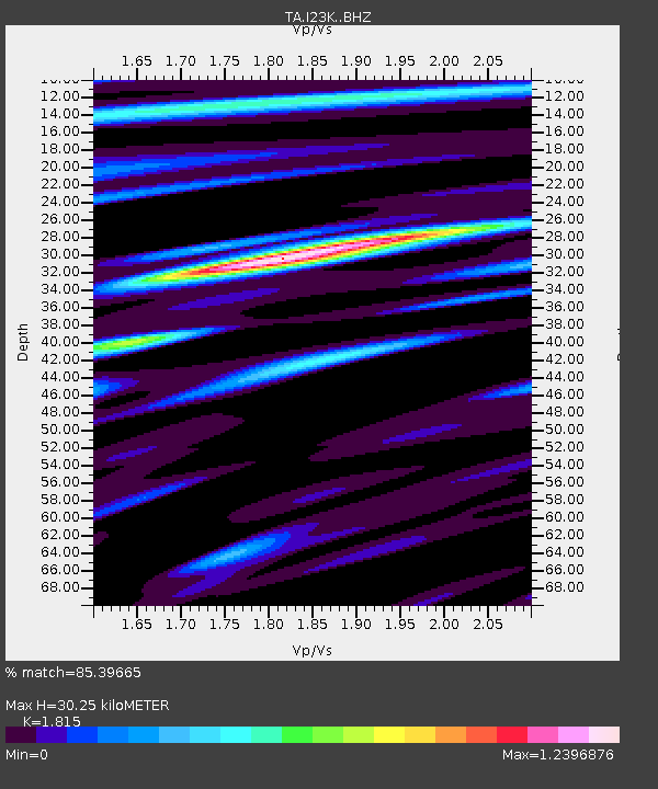
| Estimated Moho Depth: |
30.25 km |
| Estimated Crust Vp/Vs: |
1.82 |
| Assumed Crust Vp: |
6.566 km/s |
| Estimated Crust Vs: |
3.618 km/s |
| Estimated Crust Poisson's Ratio: |
0.28 |
|
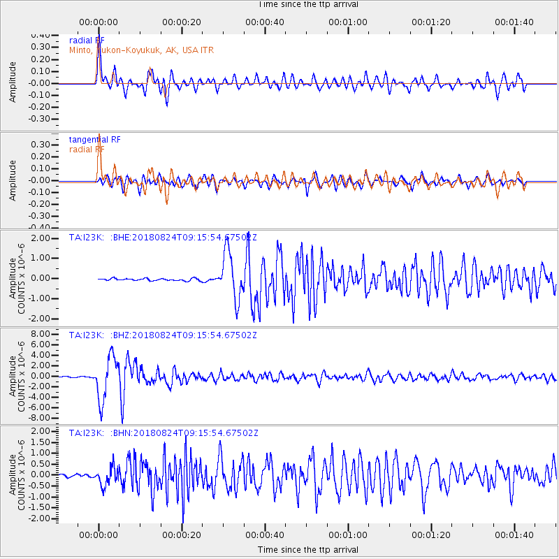
| Radial Match: |
85.39665 % |
| Radial Bump: |
400 |
| Transverse Match: |
83.535286 % |
| Transverse Bump: |
400 |
| SOD ConfigId: |
13570011 |
| Insert Time: |
2019-04-30 23:55:24.499 +0000 |
| GWidth: |
2.5 |
| Max Bumps: |
400 |
| Tol: |
0.001 |
|
Signal To Noise
| Channel | StoN | STA | LTA |
| TA:I23K: :BHZ:20180824T09:15:54.67502Z | 56.323143 | 4.2442725E-6 | 7.535575E-8 |
| TA:I23K: :BHN:20180824T09:15:54.67502Z | 6.2461042 | 4.1629755E-7 | 6.664915E-8 |
| TA:I23K: :BHE:20180824T09:15:54.67502Z | 22.640738 | 1.1948227E-6 | 5.2773142E-8 |
| Arrivals |
| Ps | 3.8 SECOND |
| PpPs | 13 SECOND |
| PsPs/PpSs | 17 SECOND |


