You are here: Home > Network List > TA - USArray Transportable Network (new EarthScope stations) Stations List
> Station L61B Northampton, MA, USA > Earthquake Result Viewer
L61B Northampton, MA, USA - Earthquake Result Viewer
| Earthquake location: |
Peru-Brazil Border Region |
| Earthquake latitude/longitude: |
-11.0/-70.8 |
| Earthquake time(UTC): |
2018/08/24 (236) 09:04:06 GMT |
| Earthquake Depth: |
609 km |
| Earthquake Magnitude: |
7.1 Mww |
| Earthquake Catalog/Contributor: |
NEIC PDE/us |
|
| Network: |
TA USArray Transportable Network (new EarthScope stations) |
| Station: |
L61B Northampton, MA, USA |
| Lat/Lon: |
42.45 N/72.68 W |
| Elevation: |
261 m |
|
| Distance: |
53.3 deg |
| Az: |
358.279 deg |
| Baz: |
177.717 deg |
| Ray Param: |
0.06348433 |
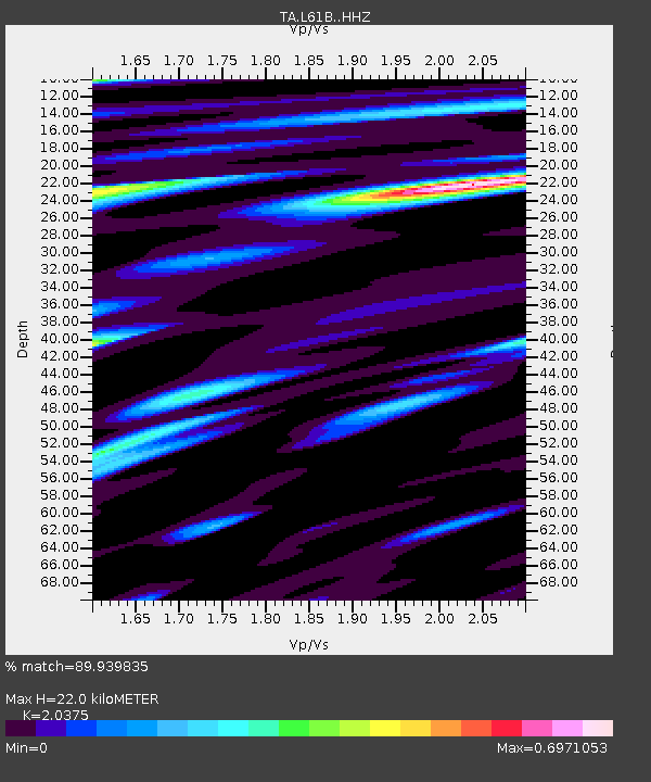
| Estimated Moho Depth: |
22.0 km |
| Estimated Crust Vp/Vs: |
2.04 |
| Assumed Crust Vp: |
6.419 km/s |
| Estimated Crust Vs: |
3.151 km/s |
| Estimated Crust Poisson's Ratio: |
0.34 |
|
| Radial Match: |
89.939835 % |
| Radial Bump: |
395 |
| Transverse Match: |
69.60315 % |
| Transverse Bump: |
400 |
| SOD ConfigId: |
13570011 |
| Insert Time: |
2019-04-30 23:55:36.137 +0000 |
| GWidth: |
2.5 |
| Max Bumps: |
400 |
| Tol: |
0.001 |
|

Signal To Noise
| Channel | StoN | STA | LTA |
| TA:L61B: :HHZ:20180824T09:11:59.320009Z | 46.972694 | 8.865122E-6 | 1.8872927E-7 |
| TA:L61B: :HHN:20180824T09:11:59.320009Z | 46.945423 | 4.591608E-6 | 9.7807366E-8 |
| TA:L61B: :HHE:20180824T09:11:59.320009Z | 9.504396 | 1.1557752E-6 | 1.2160426E-7 |
| Arrivals |
| Ps | 3.7 SECOND |
| PpPs | 10.0 SECOND |
| PsPs/PpSs | 14 SECOND |


