You are here: Home > Network List > TA - USArray Transportable Network (new EarthScope stations) Stations List
> Station N20K Mount Spurr, AK, USA > Earthquake Result Viewer
N20K Mount Spurr, AK, USA - Earthquake Result Viewer
| Earthquake location: |
Peru-Brazil Border Region |
| Earthquake latitude/longitude: |
-11.0/-70.8 |
| Earthquake time(UTC): |
2018/08/24 (236) 09:04:06 GMT |
| Earthquake Depth: |
609 km |
| Earthquake Magnitude: |
7.1 Mww |
| Earthquake Catalog/Contributor: |
NEIC PDE/us |
|
| Network: |
TA USArray Transportable Network (new EarthScope stations) |
| Station: |
N20K Mount Spurr, AK, USA |
| Lat/Lon: |
61.20 N/152.21 W |
| Elevation: |
991 m |
|
| Distance: |
95.5 deg |
| Az: |
331.251 deg |
| Baz: |
102.81 deg |
| Ray Param: |
0.040120665 |
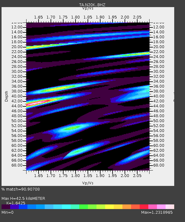
| Estimated Moho Depth: |
42.5 km |
| Estimated Crust Vp/Vs: |
1.64 |
| Assumed Crust Vp: |
6.566 km/s |
| Estimated Crust Vs: |
3.998 km/s |
| Estimated Crust Poisson's Ratio: |
0.21 |
|
| Radial Match: |
90.90708 % |
| Radial Bump: |
400 |
| Transverse Match: |
84.06924 % |
| Transverse Bump: |
400 |
| SOD ConfigId: |
13570011 |
| Insert Time: |
2019-04-30 23:55:46.086 +0000 |
| GWidth: |
2.5 |
| Max Bumps: |
400 |
| Tol: |
0.001 |
|

Signal To Noise
| Channel | StoN | STA | LTA |
| TA:N20K: :BHZ:20180824T09:15:56.024995Z | 43.477787 | 3.5261194E-6 | 8.110163E-8 |
| TA:N20K: :BHN:20180824T09:15:56.024995Z | 7.773663 | 6.9084354E-7 | 8.8869754E-8 |
| TA:N20K: :BHE:20180824T09:15:56.024995Z | 13.700224 | 1.1326106E-6 | 8.267096E-8 |
| Arrivals |
| Ps | 4.2 SECOND |
| PpPs | 17 SECOND |
| PsPs/PpSs | 21 SECOND |


