You are here: Home > Network List > TA - USArray Transportable Network (new EarthScope stations) Stations List
> Station P23K Montague Island, AK, USA > Earthquake Result Viewer
P23K Montague Island, AK, USA - Earthquake Result Viewer
| Earthquake location: |
Peru-Brazil Border Region |
| Earthquake latitude/longitude: |
-11.0/-70.8 |
| Earthquake time(UTC): |
2018/08/24 (236) 09:04:06 GMT |
| Earthquake Depth: |
609 km |
| Earthquake Magnitude: |
7.1 Mww |
| Earthquake Catalog/Contributor: |
NEIC PDE/us |
|
| Network: |
TA USArray Transportable Network (new EarthScope stations) |
| Station: |
P23K Montague Island, AK, USA |
| Lat/Lon: |
60.00 N/147.40 W |
| Elevation: |
287 m |
|
| Distance: |
92.9 deg |
| Az: |
330.695 deg |
| Baz: |
107.031 deg |
| Ray Param: |
0.040846735 |
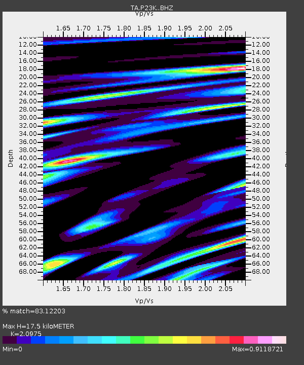
| Estimated Moho Depth: |
17.5 km |
| Estimated Crust Vp/Vs: |
2.10 |
| Assumed Crust Vp: |
5.989 km/s |
| Estimated Crust Vs: |
2.855 km/s |
| Estimated Crust Poisson's Ratio: |
0.35 |
|
| Radial Match: |
83.12203 % |
| Radial Bump: |
400 |
| Transverse Match: |
73.67608 % |
| Transverse Bump: |
400 |
| SOD ConfigId: |
13570011 |
| Insert Time: |
2019-04-30 23:55:55.938 +0000 |
| GWidth: |
2.5 |
| Max Bumps: |
400 |
| Tol: |
0.001 |
|

Signal To Noise
| Channel | StoN | STA | LTA |
| TA:P23K: :BHZ:20180824T09:15:44.350007Z | 23.233517 | 4.49915E-6 | 1.936491E-7 |
| TA:P23K: :BHN:20180824T09:15:44.350007Z | 6.120035 | 1.3399969E-6 | 2.1895248E-7 |
| TA:P23K: :BHE:20180824T09:15:44.350007Z | 8.810416 | 1.8757122E-6 | 2.128971E-7 |
| Arrivals |
| Ps | 3.3 SECOND |
| PpPs | 8.9 SECOND |
| PsPs/PpSs | 12 SECOND |


