You are here: Home > Network List > TA - USArray Transportable Network (new EarthScope stations) Stations List
> Station S34M Telegraph Creek, BC, CAN > Earthquake Result Viewer
S34M Telegraph Creek, BC, CAN - Earthquake Result Viewer
| Earthquake location: |
Peru-Brazil Border Region |
| Earthquake latitude/longitude: |
-11.0/-70.8 |
| Earthquake time(UTC): |
2018/08/24 (236) 09:04:06 GMT |
| Earthquake Depth: |
609 km |
| Earthquake Magnitude: |
7.1 Mww |
| Earthquake Catalog/Contributor: |
NEIC PDE/us |
|
| Network: |
TA USArray Transportable Network (new EarthScope stations) |
| Station: |
S34M Telegraph Creek, BC, CAN |
| Lat/Lon: |
57.91 N/131.13 W |
| Elevation: |
298 m |
|
| Distance: |
84.3 deg |
| Az: |
332.226 deg |
| Baz: |
121.012 deg |
| Ray Param: |
0.043739986 |
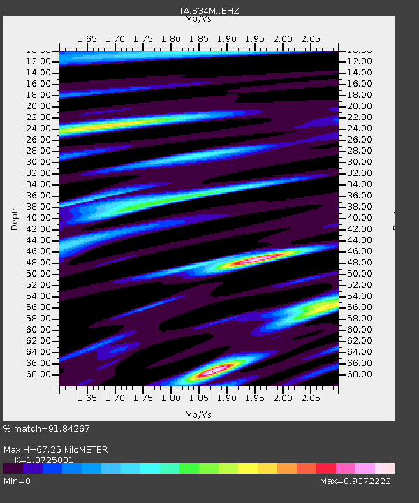
| Estimated Moho Depth: |
67.25 km |
| Estimated Crust Vp/Vs: |
1.87 |
| Assumed Crust Vp: |
6.597 km/s |
| Estimated Crust Vs: |
3.523 km/s |
| Estimated Crust Poisson's Ratio: |
0.30 |
|
| Radial Match: |
91.84267 % |
| Radial Bump: |
400 |
| Transverse Match: |
90.898445 % |
| Transverse Bump: |
400 |
| SOD ConfigId: |
13570011 |
| Insert Time: |
2019-04-30 23:56:11.231 +0000 |
| GWidth: |
2.5 |
| Max Bumps: |
400 |
| Tol: |
0.001 |
|

Signal To Noise
| Channel | StoN | STA | LTA |
| TA:S34M: :BHZ:20180824T09:15:04.725007Z | 140.19432 | 1.2581982E-5 | 8.9746734E-8 |
| TA:S34M: :BHN:20180824T09:15:04.725007Z | 22.538973 | 1.650086E-6 | 7.3210344E-8 |
| TA:S34M: :BHE:20180824T09:15:04.725007Z | 60.310093 | 3.8104502E-6 | 6.318097E-8 |
| Arrivals |
| Ps | 9.1 SECOND |
| PpPs | 29 SECOND |
| PsPs/PpSs | 38 SECOND |


