You are here: Home > Network List > TA - USArray Transportable Network (new EarthScope stations) Stations List
> Station Y22D IRIS PASSCAL Instrument Center, Socorro, NM, USA > Earthquake Result Viewer
Y22D IRIS PASSCAL Instrument Center, Socorro, NM, USA - Earthquake Result Viewer
| Earthquake location: |
Peru-Brazil Border Region |
| Earthquake latitude/longitude: |
-11.0/-70.8 |
| Earthquake time(UTC): |
2018/08/24 (236) 09:04:06 GMT |
| Earthquake Depth: |
609 km |
| Earthquake Magnitude: |
7.1 Mww |
| Earthquake Catalog/Contributor: |
NEIC PDE/us |
|
| Network: |
TA USArray Transportable Network (new EarthScope stations) |
| Station: |
Y22D IRIS PASSCAL Instrument Center, Socorro, NM, USA |
| Lat/Lon: |
34.08 N/106.92 W |
| Elevation: |
1436 m |
|
| Distance: |
56.5 deg |
| Az: |
324.085 deg |
| Baz: |
136.065 deg |
| Ray Param: |
0.06150873 |
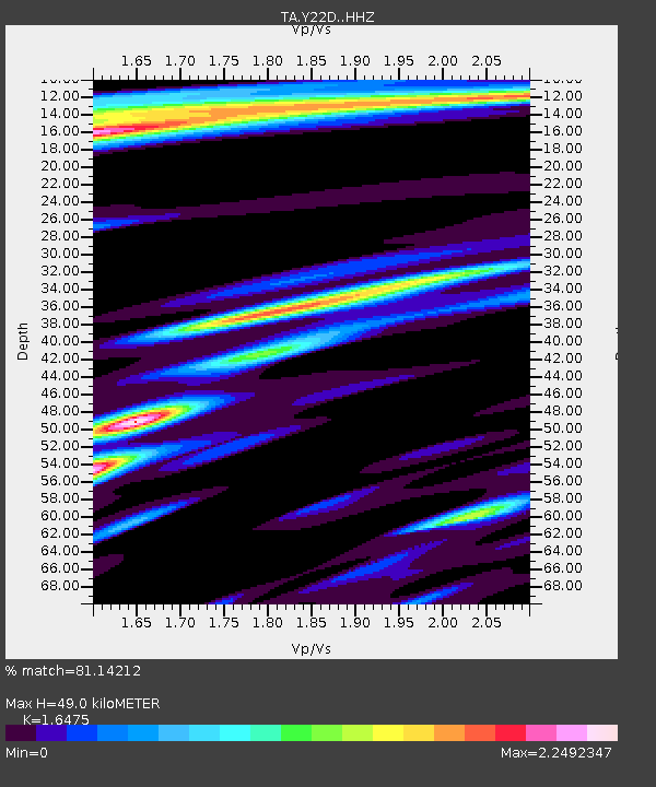
| Estimated Moho Depth: |
49.0 km |
| Estimated Crust Vp/Vs: |
1.65 |
| Assumed Crust Vp: |
6.502 km/s |
| Estimated Crust Vs: |
3.946 km/s |
| Estimated Crust Poisson's Ratio: |
0.21 |
|
| Radial Match: |
81.14212 % |
| Radial Bump: |
365 |
| Transverse Match: |
65.38259 % |
| Transverse Bump: |
400 |
| SOD ConfigId: |
13570011 |
| Insert Time: |
2019-04-30 23:56:19.618 +0000 |
| GWidth: |
2.5 |
| Max Bumps: |
400 |
| Tol: |
0.001 |
|

Signal To Noise
| Channel | StoN | STA | LTA |
| TA:Y22D: :HHZ:20180824T09:12:21.639985Z | 100.525185 | 1.4966846E-5 | 1.4888653E-7 |
| TA:Y22D: :HHN:20180824T09:12:21.639985Z | 18.622044 | 6.2625368E-6 | 3.3629695E-7 |
| TA:Y22D: :HHE:20180824T09:12:21.639985Z | 19.31159 | 7.302301E-6 | 3.7813047E-7 |
| Arrivals |
| Ps | 5.1 SECOND |
| PpPs | 19 SECOND |
| PsPs/PpSs | 24 SECOND |


