You are here: Home > Network List > TD - TransAlta Monitoring Network Stations List
> Station TD009 Z > Earthquake Result Viewer
TD009 Z - Earthquake Result Viewer
| Earthquake location: |
Peru-Brazil Border Region |
| Earthquake latitude/longitude: |
-11.0/-70.8 |
| Earthquake time(UTC): |
2018/08/24 (236) 09:04:06 GMT |
| Earthquake Depth: |
609 km |
| Earthquake Magnitude: |
7.1 Mww |
| Earthquake Catalog/Contributor: |
NEIC PDE/us |
|
| Network: |
TD TransAlta Monitoring Network |
| Station: |
TD009 Z |
| Lat/Lon: |
52.32 N/116.32 W |
| Elevation: |
1335 m |
|
| Distance: |
74.2 deg |
| Az: |
332.934 deg |
| Baz: |
133.302 deg |
| Ray Param: |
0.050463192 |
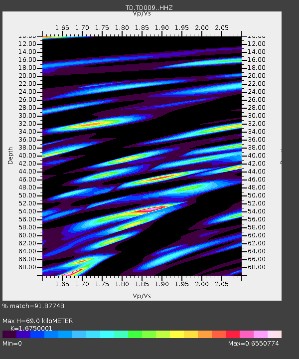
| Estimated Moho Depth: |
69.0 km |
| Estimated Crust Vp/Vs: |
1.68 |
| Assumed Crust Vp: |
6.142 km/s |
| Estimated Crust Vs: |
3.667 km/s |
| Estimated Crust Poisson's Ratio: |
0.22 |
|
| Radial Match: |
91.87748 % |
| Radial Bump: |
400 |
| Transverse Match: |
87.114525 % |
| Transverse Bump: |
400 |
| SOD ConfigId: |
13570011 |
| Insert Time: |
2019-04-30 23:56:22.929 +0000 |
| GWidth: |
2.5 |
| Max Bumps: |
400 |
| Tol: |
0.001 |
|

Signal To Noise
| Channel | StoN | STA | LTA |
| TD:TD009: :HHZ:20180824T09:14:11.75998Z | 125.2077 | 2.0366035E-5 | 1.62658E-7 |
| TD:TD009: :HH1:20180824T09:14:11.75998Z | 67.4463 | 5.8926717E-6 | 8.736835E-8 |
| TD:TD009: :HH2:20180824T09:14:11.75998Z | 74.62716 | 6.9952966E-6 | 9.37366E-8 |
| Arrivals |
| Ps | 7.8 SECOND |
| PpPs | 29 SECOND |
| PsPs/PpSs | 37 SECOND |


