You are here: Home > Network List > TD - TransAlta Monitoring Network Stations List
> Station TD010 Z > Earthquake Result Viewer
TD010 Z - Earthquake Result Viewer
| Earthquake location: |
Peru-Brazil Border Region |
| Earthquake latitude/longitude: |
-11.0/-70.8 |
| Earthquake time(UTC): |
2018/08/24 (236) 09:04:06 GMT |
| Earthquake Depth: |
609 km |
| Earthquake Magnitude: |
7.1 Mww |
| Earthquake Catalog/Contributor: |
NEIC PDE/us |
|
| Network: |
TD TransAlta Monitoring Network |
| Station: |
TD010 Z |
| Lat/Lon: |
52.64 N/116.33 W |
| Elevation: |
1637 m |
|
| Distance: |
74.4 deg |
| Az: |
333.17 deg |
| Baz: |
133.358 deg |
| Ray Param: |
0.05031983 |
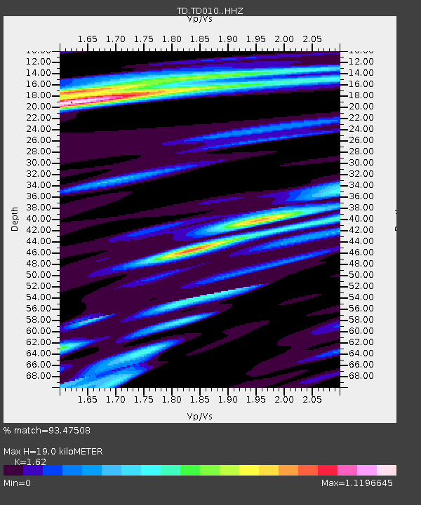
| Estimated Moho Depth: |
19.0 km |
| Estimated Crust Vp/Vs: |
1.62 |
| Assumed Crust Vp: |
6.142 km/s |
| Estimated Crust Vs: |
3.791 km/s |
| Estimated Crust Poisson's Ratio: |
0.19 |
|
| Radial Match: |
93.47508 % |
| Radial Bump: |
400 |
| Transverse Match: |
89.13367 % |
| Transverse Bump: |
400 |
| SOD ConfigId: |
13570011 |
| Insert Time: |
2019-04-30 23:56:23.178 +0000 |
| GWidth: |
2.5 |
| Max Bumps: |
400 |
| Tol: |
0.001 |
|

Signal To Noise
| Channel | StoN | STA | LTA |
| TD:TD010: :HHZ:20180824T09:14:12.999971Z | 139.95958 | 2.3932784E-5 | 1.7099782E-7 |
| TD:TD010: :HH1:20180824T09:14:12.999971Z | 74.80492 | 7.3718084E-6 | 9.854711E-8 |
| TD:TD010: :HH2:20180824T09:14:12.999971Z | 36.95965 | 5.1151237E-6 | 1.3839752E-7 |
| Arrivals |
| Ps | 2.0 SECOND |
| PpPs | 7.9 SECOND |
| PsPs/PpSs | 9.8 SECOND |


