You are here: Home > Network List > TA - USArray Transportable Network (new EarthScope stations) Stations List
> Station S19A Harvey Farm, Monticello, UT, USA > Earthquake Result Viewer
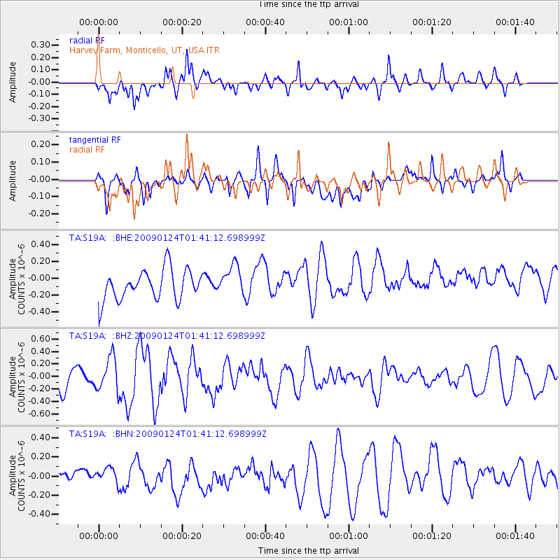
S19A Harvey Farm, Monticello, UT, USA - Earthquake Result Viewer
*The percent match for this event was below the threshold and hence no stack was calculated.
| Earthquake location: |
Kermadec Islands Region |
| Earthquake latitude/longitude: |
-28.2/-176.7 |
| Earthquake time(UTC): |
2009/01/24 (024) 01:28:39 GMT |
| Earthquake Depth: |
10 km |
| Earthquake Magnitude: |
5.5 MB, 5.8 MS, 6.0 MW, 5.8 MW |
| Earthquake Catalog/Contributor: |
WHDF/NEIC |
|
| Network: |
TA USArray Transportable Network (new EarthScope stations) |
| Station: |
S19A Harvey Farm, Monticello, UT, USA |
| Lat/Lon: |
37.75 N/109.14 W |
| Elevation: |
2059 m |
|
| Distance: |
91.2 deg |
| Az: |
47.125 deg |
| Baz: |
234.644 deg |
| Ray Param: |
$rayparam |
*The percent match for this event was below the threshold and hence was not used in the summary stack. |
|
| Radial Match: |
58.64437 % |
| Radial Bump: |
400 |
| Transverse Match: |
45.85685 % |
| Transverse Bump: |
400 |
| SOD ConfigId: |
2658 |
| Insert Time: |
2010-03-06 14:47:03.212 +0000 |
| GWidth: |
2.5 |
| Max Bumps: |
400 |
| Tol: |
0.001 |
|
Signal To Noise
| Channel | StoN | STA | LTA |
| TA:S19A: :BHZ:20090124T01:41:12.698999Z | 1.558766 | 2.7694125E-7 | 1.7766698E-7 |
| TA:S19A: :BHN:20090124T01:41:12.698999Z | 0.56098866 | 7.143806E-8 | 1.2734314E-7 |
| TA:S19A: :BHE:20090124T01:41:12.698999Z | 1.0479984 | 1.8636581E-7 | 1.7783023E-7 |
| Arrivals |
| Ps | |
| PpPs | |
| PsPs/PpSs | |


