You are here: Home > Network List > UO - University of Oregon Regional Network Stations List
> Station CAVE Cave Junction, OR, USA > Earthquake Result Viewer
CAVE Cave Junction, OR, USA - Earthquake Result Viewer
| Earthquake location: |
Peru-Brazil Border Region |
| Earthquake latitude/longitude: |
-11.0/-70.8 |
| Earthquake time(UTC): |
2018/08/24 (236) 09:04:06 GMT |
| Earthquake Depth: |
609 km |
| Earthquake Magnitude: |
7.1 Mww |
| Earthquake Catalog/Contributor: |
NEIC PDE/us |
|
| Network: |
UO University of Oregon Regional Network |
| Station: |
CAVE Cave Junction, OR, USA |
| Lat/Lon: |
42.12 N/123.57 W |
| Elevation: |
440 m |
|
| Distance: |
71.6 deg |
| Az: |
321.393 deg |
| Baz: |
124.575 deg |
| Ray Param: |
0.05209428 |
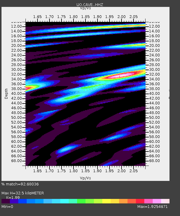
| Estimated Moho Depth: |
32.5 km |
| Estimated Crust Vp/Vs: |
1.99 |
| Assumed Crust Vp: |
6.522 km/s |
| Estimated Crust Vs: |
3.277 km/s |
| Estimated Crust Poisson's Ratio: |
0.33 |
|
| Radial Match: |
92.68036 % |
| Radial Bump: |
400 |
| Transverse Match: |
88.53932 % |
| Transverse Bump: |
400 |
| SOD ConfigId: |
13570011 |
| Insert Time: |
2019-04-30 23:56:43.440 +0000 |
| GWidth: |
2.5 |
| Max Bumps: |
400 |
| Tol: |
0.001 |
|

Signal To Noise
| Channel | StoN | STA | LTA |
| UO:CAVE: :HHZ:20180824T09:13:57.168Z | 86.76869 | 1.2279165E-5 | 1.4151608E-7 |
| UO:CAVE: :HHN:20180824T09:13:57.168Z | 27.558388 | 3.1223315E-6 | 1.1329877E-7 |
| UO:CAVE: :HHE:20180824T09:13:57.168Z | 37.45254 | 4.876383E-6 | 1.3020167E-7 |
| Arrivals |
| Ps | 5.1 SECOND |
| PpPs | 14 SECOND |
| PsPs/PpSs | 20 SECOND |


