You are here: Home > Network List > WU - The Southern Ontario Seismic Network Stations List
> Station BMRO Meriville Lake, Ontario, Canada > Earthquake Result Viewer
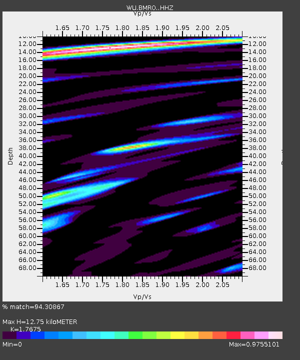
BMRO Meriville Lake, Ontario, Canada - Earthquake Result Viewer
| Earthquake location: |
Peru-Brazil Border Region |
| Earthquake latitude/longitude: |
-11.0/-70.8 |
| Earthquake time(UTC): |
2018/08/24 (236) 09:04:06 GMT |
| Earthquake Depth: |
609 km |
| Earthquake Magnitude: |
7.1 Mww |
| Earthquake Catalog/Contributor: |
NEIC PDE/us |
|
| Network: |
WU The Southern Ontario Seismic Network |
| Station: |
BMRO Meriville Lake, Ontario, Canada |
| Lat/Lon: |
44.60 N/81.22 W |
| Elevation: |
217 m |
|
| Distance: |
56.2 deg |
| Az: |
351.068 deg |
| Baz: |
167.681 deg |
| Ray Param: |
0.061702814 |
| Estimated Moho Depth: |
12.75 km |
| Estimated Crust Vp/Vs: |
1.77 |
| Assumed Crust Vp: |
6.53 km/s |
| Estimated Crust Vs: |
3.695 km/s |
| Estimated Crust Poisson's Ratio: |
0.26 |
|
| Radial Match: |
94.30867 % |
| Radial Bump: |
333 |
| Transverse Match: |
82.47211 % |
| Transverse Bump: |
400 |
| SOD ConfigId: |
13570011 |
| Insert Time: |
2019-04-30 23:57:44.190 +0000 |
| GWidth: |
2.5 |
| Max Bumps: |
400 |
| Tol: |
0.001 |
|

Signal To Noise
| Channel | StoN | STA | LTA |
| WU:BMRO: :HHZ:20180824T09:12:19.549989Z | 97.861046 | 2.1529366E-5 | 2.1999935E-7 |
| WU:BMRO: :HHN:20180824T09:12:19.549989Z | 20.879873 | 9.2905875E-6 | 4.4495422E-7 |
| WU:BMRO: :HHE:20180824T09:12:19.549989Z | 18.716269 | 2.674674E-6 | 1.4290637E-7 |
| Arrivals |
| Ps | 1.6 SECOND |
| PpPs | 5.1 SECOND |
| PsPs/PpSs | 6.7 SECOND |


