You are here: Home > Network List > TA - USArray Transportable Network (new EarthScope stations) Stations List
> Station S17A Black Ridge (BLM), Bullfrog Basin, UT, USA > Earthquake Result Viewer
S17A Black Ridge (BLM), Bullfrog Basin, UT, USA - Earthquake Result Viewer
| Earthquake location: |
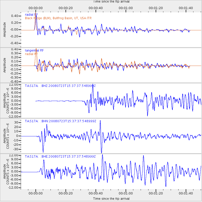
Eastern Honshu, Japan |
| Earthquake latitude/longitude: |
39.8/141.5 |
| Earthquake time(UTC): |
2008/07/23 (205) 15:26:19 GMT |
| Earthquake Depth: |
108 km |
| Earthquake Magnitude: |
6.6 MB, 6.8 MW, 6.8 MW |
| Earthquake Catalog/Contributor: |
WHDF/NEIC |
|
| Network: |
TA USArray Transportable Network (new EarthScope stations) |
| Station: |
S17A Black Ridge (BLM), Bullfrog Basin, UT, USA |
| Lat/Lon: |
37.64 N/110.80 W |
| Elevation: |
1373 m |
|
| Distance: |
78.4 deg |
| Az: |
50.532 deg |
| Baz: |
311.486 deg |
| Ray Param: |
0.049432702 |
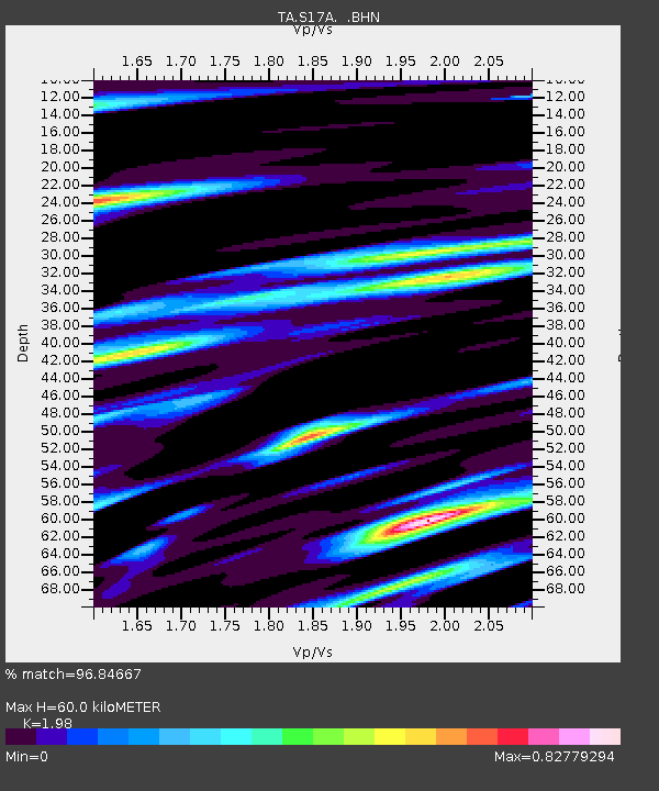
| Estimated Moho Depth: |
60.0 km |
| Estimated Crust Vp/Vs: |
1.98 |
| Assumed Crust Vp: |
6.247 km/s |
| Estimated Crust Vs: |
3.155 km/s |
| Estimated Crust Poisson's Ratio: |
0.33 |
|
| Radial Match: |
96.84667 % |
| Radial Bump: |
398 |
| Transverse Match: |
93.85854 % |
| Transverse Bump: |
400 |
| SOD ConfigId: |
2504 |
| Insert Time: |
2010-03-06 14:47:45.188 +0000 |
| GWidth: |
2.5 |
| Max Bumps: |
400 |
| Tol: |
0.001 |
|
Signal To Noise
| Channel | StoN | STA | LTA |
| TA:S17A: :BHN:20080723T15:37:37.548999Z | 63.575336 | 7.5768244E-6 | 1.1917868E-7 |
| TA:S17A: :BHE:20080723T15:37:37.548999Z | 7.814638 | 1.0777761E-6 | 1.3791761E-7 |
| TA:S17A: :BHZ:20080723T15:37:37.548999Z | 9.728355 | 1.1064487E-6 | 1.1373441E-7 |
| Arrivals |
| Ps | 9.6 SECOND |
| PpPs | 28 SECOND |
| PsPs/PpSs | 38 SECOND |


