You are here: Home > Network List > TA - USArray Transportable Network (new EarthScope stations) Stations List
> Station S17A Black Ridge (BLM), Bullfrog Basin, UT, USA > Earthquake Result Viewer
S17A Black Ridge (BLM), Bullfrog Basin, UT, USA - Earthquake Result Viewer
| Earthquake location: |
North Of Severnaya Zemlya |
| Earthquake latitude/longitude: |
83.6/115.2 |
| Earthquake time(UTC): |
2008/08/13 (226) 08:35:02 GMT |
| Earthquake Depth: |
10 km |
| Earthquake Magnitude: |
5.5 MB, 4.7 MS, 5.4 MW, 5.4 MW |
| Earthquake Catalog/Contributor: |
WHDF/NEIC |
|
| Network: |
TA USArray Transportable Network (new EarthScope stations) |
| Station: |
S17A Black Ridge (BLM), Bullfrog Basin, UT, USA |
| Lat/Lon: |
37.64 N/110.80 W |
| Elevation: |
1373 m |
|
| Distance: |
57.1 deg |
| Az: |
42.884 deg |
| Baz: |
354.516 deg |
| Ray Param: |
0.06369242 |
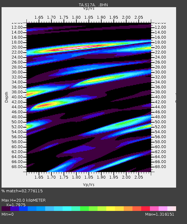
| Estimated Moho Depth: |
20.0 km |
| Estimated Crust Vp/Vs: |
1.80 |
| Assumed Crust Vp: |
6.247 km/s |
| Estimated Crust Vs: |
3.475 km/s |
| Estimated Crust Poisson's Ratio: |
0.28 |
|
| Radial Match: |
82.776115 % |
| Radial Bump: |
400 |
| Transverse Match: |
75.39593 % |
| Transverse Bump: |
400 |
| SOD ConfigId: |
2504 |
| Insert Time: |
2010-03-06 14:47:52.926 +0000 |
| GWidth: |
2.5 |
| Max Bumps: |
400 |
| Tol: |
0.001 |
|
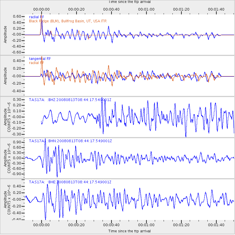
Signal To Noise
| Channel | StoN | STA | LTA |
| TA:S17A: :BHN:20080813T08:44:17.549001Z | 12.153405 | 5.1364316E-7 | 4.2263313E-8 |
| TA:S17A: :BHE:20080813T08:44:17.549001Z | 4.0243587 | 2.5106476E-7 | 6.238628E-8 |
| TA:S17A: :BHZ:20080813T08:44:17.549001Z | 1.7011778 | 1.0469314E-7 | 6.154156E-8 |
| Arrivals |
| Ps | 2.7 SECOND |
| PpPs | 8.5 SECOND |
| PsPs/PpSs | 11 SECOND |


