You are here: Home > Network List > TA - USArray Transportable Network (new EarthScope stations) Stations List
> Station S17A Black Ridge (BLM), Bullfrog Basin, UT, USA > Earthquake Result Viewer
S17A Black Ridge (BLM), Bullfrog Basin, UT, USA - Earthquake Result Viewer
| Earthquake location: |
Peru-Brazil Border Region |
| Earthquake latitude/longitude: |
-7.6/-74.4 |
| Earthquake time(UTC): |
2008/08/26 (239) 21:00:36 GMT |
| Earthquake Depth: |
154 km |
| Earthquake Magnitude: |
6.0 MB, 6.4 MW, 6.4 MW |
| Earthquake Catalog/Contributor: |
WHDF/NEIC |
|
| Network: |
TA USArray Transportable Network (new EarthScope stations) |
| Station: |
S17A Black Ridge (BLM), Bullfrog Basin, UT, USA |
| Lat/Lon: |
37.64 N/110.80 W |
| Elevation: |
1373 m |
|
| Distance: |
56.4 deg |
| Az: |
325.548 deg |
| Baz: |
135.062 deg |
| Ray Param: |
0.06364492 |
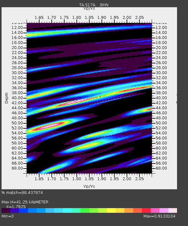
| Estimated Moho Depth: |
41.25 km |
| Estimated Crust Vp/Vs: |
1.79 |
| Assumed Crust Vp: |
6.247 km/s |
| Estimated Crust Vs: |
3.485 km/s |
| Estimated Crust Poisson's Ratio: |
0.27 |
|
| Radial Match: |
88.437874 % |
| Radial Bump: |
400 |
| Transverse Match: |
78.93535 % |
| Transverse Bump: |
400 |
| SOD ConfigId: |
2504 |
| Insert Time: |
2010-03-06 14:47:56.592 +0000 |
| GWidth: |
2.5 |
| Max Bumps: |
400 |
| Tol: |
0.001 |
|
Signal To Noise
| Channel | StoN | STA | LTA |
| TA:S17A: :BHN:20080826T21:09:31.524001Z | 21.925777 | 1.8016253E-6 | 8.216928E-8 |
| TA:S17A: :BHE:20080826T21:09:31.524001Z | 6.91875 | 5.806042E-7 | 8.3917506E-8 |
| TA:S17A: :BHZ:20080826T21:09:31.524001Z | 8.673906 | 6.3792015E-7 | 7.354473E-8 |
| Arrivals |
| Ps | 5.5 SECOND |
| PpPs | 18 SECOND |
| PsPs/PpSs | 23 SECOND |


