You are here: Home > Network List > TA - USArray Transportable Network (new EarthScope stations) Stations List
> Station S17A Black Ridge (BLM), Bullfrog Basin, UT, USA > Earthquake Result Viewer
S17A Black Ridge (BLM), Bullfrog Basin, UT, USA - Earthquake Result Viewer
| Earthquake location: |
Colombia |
| Earthquake latitude/longitude: |
4.8/-75.5 |
| Earthquake time(UTC): |
2008/09/13 (257) 09:32:01 GMT |
| Earthquake Depth: |
133 km |
| Earthquake Magnitude: |
5.9 MB, 5.7 MW, 5.7 MW |
| Earthquake Catalog/Contributor: |
WHDF/NEIC |
|
| Network: |
TA USArray Transportable Network (new EarthScope stations) |
| Station: |
S17A Black Ridge (BLM), Bullfrog Basin, UT, USA |
| Lat/Lon: |
37.64 N/110.80 W |
| Elevation: |
1373 m |
|
| Distance: |
45.9 deg |
| Az: |
320.292 deg |
| Baz: |
126.682 deg |
| Ray Param: |
0.07053673 |
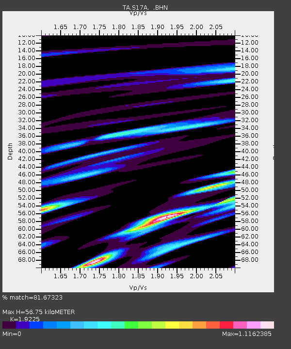
| Estimated Moho Depth: |
56.75 km |
| Estimated Crust Vp/Vs: |
1.92 |
| Assumed Crust Vp: |
6.247 km/s |
| Estimated Crust Vs: |
3.249 km/s |
| Estimated Crust Poisson's Ratio: |
0.31 |
|
| Radial Match: |
81.67323 % |
| Radial Bump: |
376 |
| Transverse Match: |
74.85645 % |
| Transverse Bump: |
375 |
| SOD ConfigId: |
2560 |
| Insert Time: |
2010-03-06 14:48:06.354 +0000 |
| GWidth: |
2.5 |
| Max Bumps: |
400 |
| Tol: |
0.001 |
|
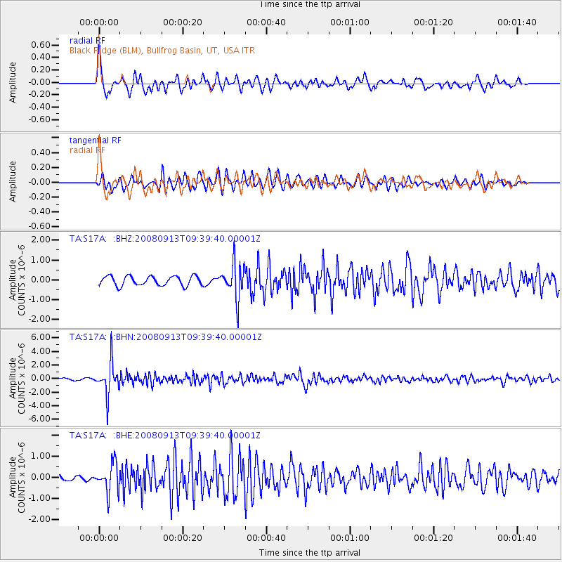
Signal To Noise
| Channel | StoN | STA | LTA |
| TA:S17A: :BHN:20080913T09:39:40.00001Z | 11.345376 | 2.3508808E-6 | 2.0721048E-7 |
| TA:S17A: :BHE:20080913T09:39:40.00001Z | 2.7992005 | 6.840963E-7 | 2.4438987E-7 |
| TA:S17A: :BHZ:20080913T09:39:40.00001Z | 3.8087893 | 8.9286516E-7 | 2.3442232E-7 |
| Arrivals |
| Ps | 8.8 SECOND |
| PpPs | 25 SECOND |
| PsPs/PpSs | 34 SECOND |


