You are here: Home > Network List > TA - USArray Transportable Network (new EarthScope stations) Stations List
> Station S17A Black Ridge (BLM), Bullfrog Basin, UT, USA > Earthquake Result Viewer
S17A Black Ridge (BLM), Bullfrog Basin, UT, USA - Earthquake Result Viewer
| Earthquake location: |
East Of Kuril Islands |
| Earthquake latitude/longitude: |
46.9/155.2 |
| Earthquake time(UTC): |
2009/01/15 (015) 17:49:39 GMT |
| Earthquake Depth: |
36 km |
| Earthquake Magnitude: |
6.9 MB, 7.5 MS, 7.4 MW, 7.4 MW |
| Earthquake Catalog/Contributor: |
WHDF/NEIC |
|
| Network: |
TA USArray Transportable Network (new EarthScope stations) |
| Station: |
S17A Black Ridge (BLM), Bullfrog Basin, UT, USA |
| Lat/Lon: |
37.64 N/110.80 W |
| Elevation: |
1373 m |
|
| Distance: |
66.2 deg |
| Az: |
59.956 deg |
| Baz: |
311.557 deg |
| Ray Param: |
0.057724442 |
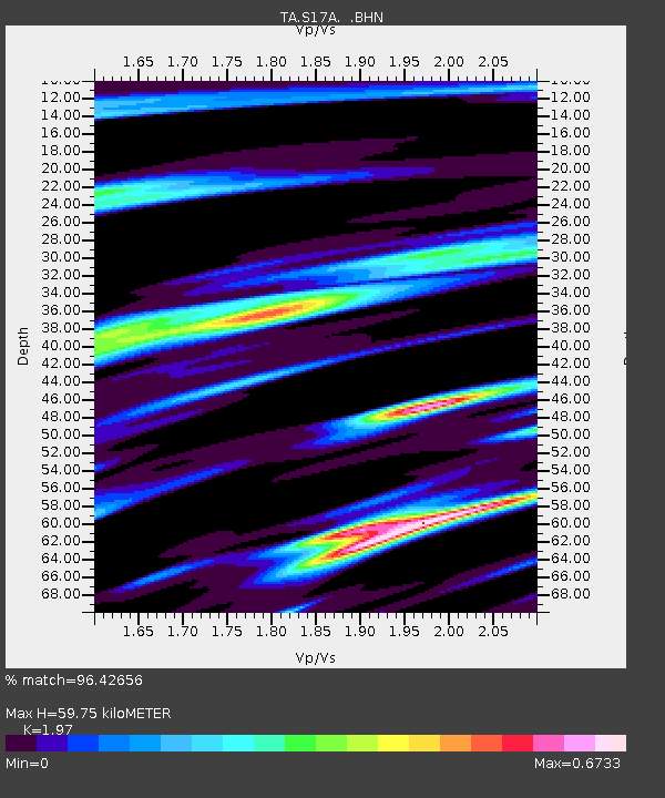
| Estimated Moho Depth: |
59.75 km |
| Estimated Crust Vp/Vs: |
1.97 |
| Assumed Crust Vp: |
6.247 km/s |
| Estimated Crust Vs: |
3.171 km/s |
| Estimated Crust Poisson's Ratio: |
0.33 |
|
| Radial Match: |
96.42656 % |
| Radial Bump: |
400 |
| Transverse Match: |
94.225914 % |
| Transverse Bump: |
400 |
| SOD ConfigId: |
2834 |
| Insert Time: |
2010-03-06 14:48:18.465 +0000 |
| GWidth: |
2.5 |
| Max Bumps: |
400 |
| Tol: |
0.001 |
|
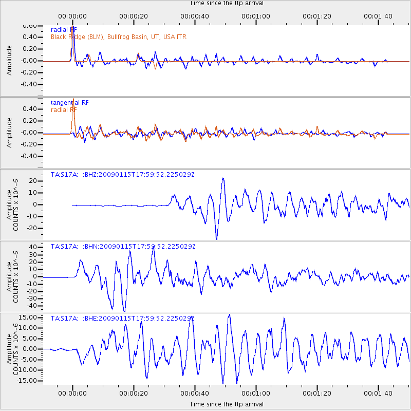
Signal To Noise
| Channel | StoN | STA | LTA |
| TA:S17A: :BHN:20090115T17:59:52.225029Z | 44.75858 | 1.13525375E-5 | 2.5363937E-7 |
| TA:S17A: :BHE:20090115T17:59:52.225029Z | 11.321218 | 3.436639E-6 | 3.0355739E-7 |
| TA:S17A: :BHZ:20090115T17:59:52.225029Z | 16.73881 | 4.194282E-6 | 2.5057233E-7 |
| Arrivals |
| Ps | 9.6 SECOND |
| PpPs | 27 SECOND |
| PsPs/PpSs | 37 SECOND |


