You are here: Home > Network List > CI - Caltech Regional Seismic Network Stations List
> Station MPM Manuel Prospect Mine, California, USA > Earthquake Result Viewer
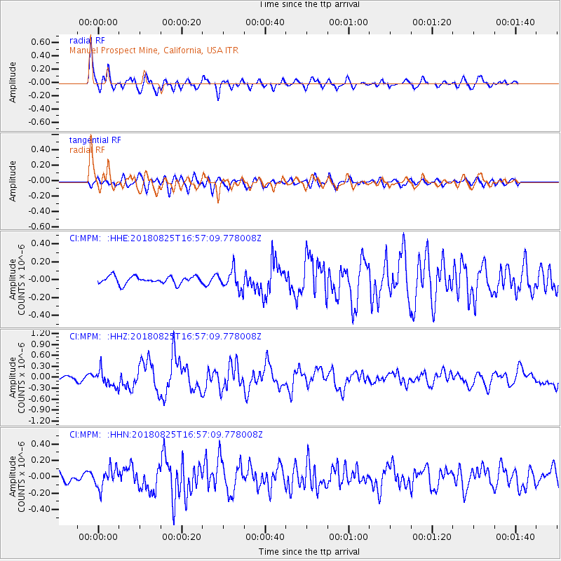
MPM Manuel Prospect Mine, California, USA - Earthquake Result Viewer
*The percent match for this event was below the threshold and hence no stack was calculated.
| Earthquake location: |
Fox Islands, Aleutian Islands |
| Earthquake latitude/longitude: |
52.3/-171.2 |
| Earthquake time(UTC): |
2018/08/25 (237) 16:50:04 GMT |
| Earthquake Depth: |
35 km |
| Earthquake Magnitude: |
5.5 Ml |
| Earthquake Catalog/Contributor: |
NEIC PDE/us |
|
| Network: |
CI Caltech Regional Seismic Network |
| Station: |
MPM Manuel Prospect Mine, California, USA |
| Lat/Lon: |
36.06 N/117.49 W |
| Elevation: |
185 m |
|
| Distance: |
40.8 deg |
| Az: |
91.632 deg |
| Baz: |
310.733 deg |
| Ray Param: |
$rayparam |
*The percent match for this event was below the threshold and hence was not used in the summary stack. |
|
| Radial Match: |
81.60965 % |
| Radial Bump: |
400 |
| Transverse Match: |
66.19888 % |
| Transverse Bump: |
400 |
| SOD ConfigId: |
13570011 |
| Insert Time: |
2019-05-01 00:05:54.129 +0000 |
| GWidth: |
2.5 |
| Max Bumps: |
400 |
| Tol: |
0.001 |
|
Signal To Noise
| Channel | StoN | STA | LTA |
| CI:MPM: :HHZ:20180825T16:57:09.778008Z | 3.815587 | 2.229011E-7 | 5.8418557E-8 |
| CI:MPM: :HHN:20180825T16:57:09.778008Z | 2.0843987 | 1.2108667E-7 | 5.809189E-8 |
| CI:MPM: :HHE:20180825T16:57:09.778008Z | 2.535742 | 1.131072E-7 | 4.4605166E-8 |
| Arrivals |
| Ps | |
| PpPs | |
| PsPs/PpSs | |


