You are here: Home > Network List > TA - USArray Transportable Network (new EarthScope stations) Stations List
> Station S17A Black Ridge (BLM), Bullfrog Basin, UT, USA > Earthquake Result Viewer
S17A Black Ridge (BLM), Bullfrog Basin, UT, USA - Earthquake Result Viewer
| Earthquake location: |
Mariana Islands |
| Earthquake latitude/longitude: |
18.9/145.4 |
| Earthquake time(UTC): |
2007/10/31 (304) 03:30:17 GMT |
| Earthquake Depth: |
223 km |
| Earthquake Magnitude: |
6.2 MB, 7.2 MW, 7.2 MW |
| Earthquake Catalog/Contributor: |
WHDF/NEIC |
|
| Network: |
TA USArray Transportable Network (new EarthScope stations) |
| Station: |
S17A Black Ridge (BLM), Bullfrog Basin, UT, USA |
| Lat/Lon: |
37.64 N/110.80 W |
| Elevation: |
1373 m |
|
| Distance: |
89.1 deg |
| Az: |
50.44 deg |
| Baz: |
293.159 deg |
| Ray Param: |
0.041720197 |
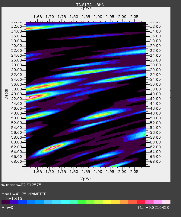
| Estimated Moho Depth: |
41.25 km |
| Estimated Crust Vp/Vs: |
1.62 |
| Assumed Crust Vp: |
6.247 km/s |
| Estimated Crust Vs: |
3.868 km/s |
| Estimated Crust Poisson's Ratio: |
0.19 |
|
| Radial Match: |
87.912575 % |
| Radial Bump: |
400 |
| Transverse Match: |
84.60695 % |
| Transverse Bump: |
395 |
| SOD ConfigId: |
2564 |
| Insert Time: |
2010-03-06 14:48:28.501 +0000 |
| GWidth: |
2.5 |
| Max Bumps: |
400 |
| Tol: |
0.001 |
|
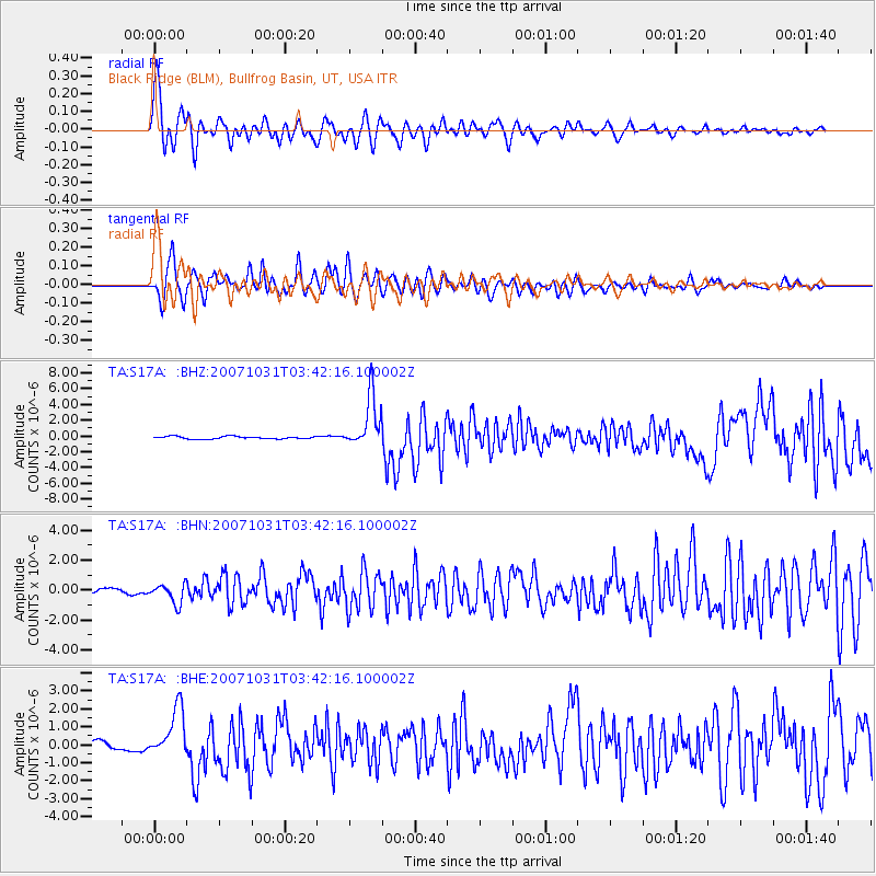
Signal To Noise
| Channel | StoN | STA | LTA |
| TA:S17A: :BHN:20071031T03:42:16.100002Z | 2.5444367 | 6.4276895E-7 | 2.5261738E-7 |
| TA:S17A: :BHE:20071031T03:42:16.100002Z | 7.39369 | 1.3488602E-6 | 1.8243395E-7 |
| TA:S17A: :BHZ:20071031T03:42:16.100002Z | 21.009985 | 3.293462E-6 | 1.56757E-7 |
| Arrivals |
| Ps | 4.1 SECOND |
| PpPs | 17 SECOND |
| PsPs/PpSs | 21 SECOND |


