You are here: Home > Network List > IU - Global Seismograph Network (GSN - IRIS/USGS) Stations List
> Station PMG Port Moresby, New Guinea > Earthquake Result Viewer
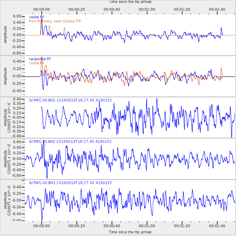
PMG Port Moresby, New Guinea - Earthquake Result Viewer
*The percent match for this event was below the threshold and hence no stack was calculated.
| Earthquake location: |
Philippine Islands Region |
| Earthquake latitude/longitude: |
20.1/121.4 |
| Earthquake time(UTC): |
2016/06/19 (171) 18:20:50 GMT |
| Earthquake Depth: |
18 km |
| Earthquake Magnitude: |
5.6 MWW, 5.4 MWB |
| Earthquake Catalog/Contributor: |
NEIC PDE/NEIC COMCAT |
|
| Network: |
IU Global Seismograph Network (GSN - IRIS/USGS) |
| Station: |
PMG Port Moresby, New Guinea |
| Lat/Lon: |
9.40 S/147.16 E |
| Elevation: |
90 m |
|
| Distance: |
38.8 deg |
| Az: |
136.796 deg |
| Baz: |
319.315 deg |
| Ray Param: |
$rayparam |
*The percent match for this event was below the threshold and hence was not used in the summary stack. |
|
| Radial Match: |
59.951088 % |
| Radial Bump: |
400 |
| Transverse Match: |
55.115665 % |
| Transverse Bump: |
400 |
| SOD ConfigId: |
1634031 |
| Insert Time: |
2016-07-18 15:42:32.883 +0000 |
| GWidth: |
2.5 |
| Max Bumps: |
400 |
| Tol: |
0.001 |
|
Signal To Noise
| Channel | StoN | STA | LTA |
| IU:PMG:00:BHZ:20160619T18:27:43.419015Z | 2.4749837 | 3.027411E-7 | 1.2232044E-7 |
| IU:PMG:00:BH1:20160619T18:27:43.419015Z | 2.3268852 | 2.2878285E-7 | 9.83215E-8 |
| IU:PMG:00:BH2:20160619T18:27:43.419015Z | 1.3671608 | 1.5584865E-7 | 1.1399439E-7 |
| Arrivals |
| Ps | |
| PpPs | |
| PsPs/PpSs | |


