You are here: Home > Network List > TA - USArray Transportable Network (new EarthScope stations) Stations List
> Station S17A Black Ridge (BLM), Bullfrog Basin, UT, USA > Earthquake Result Viewer
S17A Black Ridge (BLM), Bullfrog Basin, UT, USA - Earthquake Result Viewer
| Earthquake location: |
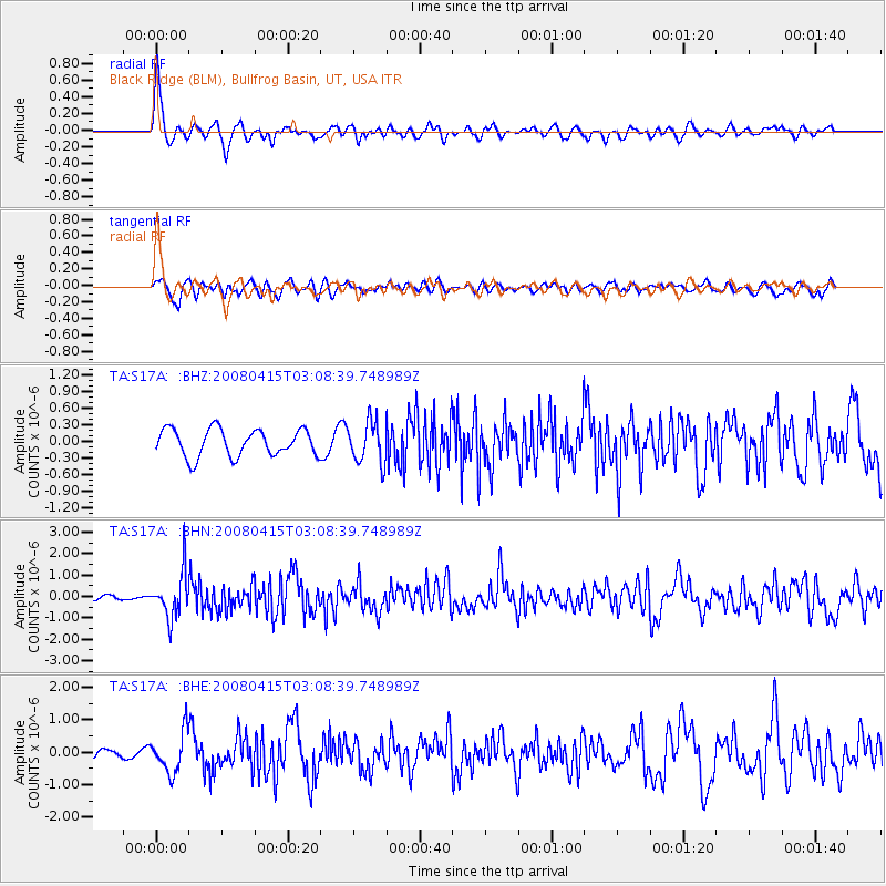
Near Coast Of Guatemala |
| Earthquake latitude/longitude: |
13.6/-90.6 |
| Earthquake time(UTC): |
2008/04/15 (106) 03:03:04 GMT |
| Earthquake Depth: |
33 km |
| Earthquake Magnitude: |
5.6 MB, 5.8 MS, 6.1 MW, 6.1 MW |
| Earthquake Catalog/Contributor: |
WHDF/NEIC |
|
| Network: |
TA USArray Transportable Network (new EarthScope stations) |
| Station: |
S17A Black Ridge (BLM), Bullfrog Basin, UT, USA |
| Lat/Lon: |
37.64 N/110.80 W |
| Elevation: |
1373 m |
|
| Distance: |
30.0 deg |
| Az: |
326.72 deg |
| Baz: |
137.765 deg |
| Ray Param: |
0.07942255 |
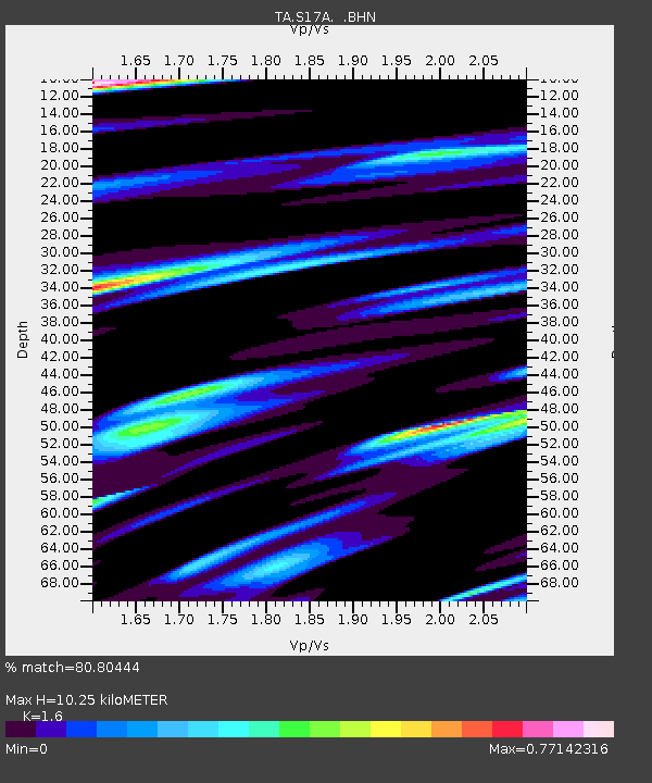
| Estimated Moho Depth: |
10.25 km |
| Estimated Crust Vp/Vs: |
1.60 |
| Assumed Crust Vp: |
6.247 km/s |
| Estimated Crust Vs: |
3.904 km/s |
| Estimated Crust Poisson's Ratio: |
0.18 |
|
| Radial Match: |
80.80444 % |
| Radial Bump: |
400 |
| Transverse Match: |
63.22468 % |
| Transverse Bump: |
400 |
| SOD ConfigId: |
2504 |
| Insert Time: |
2010-03-06 14:49:00.074 +0000 |
| GWidth: |
2.5 |
| Max Bumps: |
400 |
| Tol: |
0.001 |
|
Signal To Noise
| Channel | StoN | STA | LTA |
| TA:S17A: :BHN:20080415T03:08:39.748989Z | 5.4892416 | 1.030313E-6 | 1.8769677E-7 |
| TA:S17A: :BHE:20080415T03:08:39.748989Z | 3.6284552 | 6.210531E-7 | 1.7116184E-7 |
| TA:S17A: :BHZ:20080415T03:08:39.748989Z | 1.5247114 | 3.7288874E-7 | 2.445635E-7 |
| Arrivals |
| Ps | 1.1 SECOND |
| PpPs | 3.9 SECOND |
| PsPs/PpSs | 5.0 SECOND |


