You are here: Home > Network List > TA - USArray Transportable Network (new EarthScope stations) Stations List
> Station S17A Black Ridge (BLM), Bullfrog Basin, UT, USA > Earthquake Result Viewer
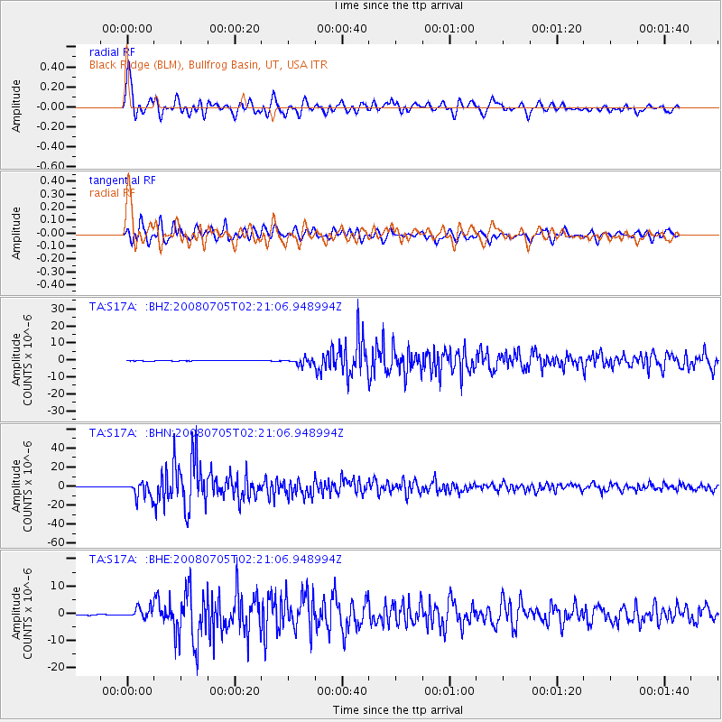
S17A Black Ridge (BLM), Bullfrog Basin, UT, USA - Earthquake Result Viewer
| Earthquake location: |
Sea Of Okhotsk |
| Earthquake latitude/longitude: |
53.9/152.9 |
| Earthquake time(UTC): |
2008/07/05 (187) 02:12:04 GMT |
| Earthquake Depth: |
633 km |
| Earthquake Magnitude: |
6.8 MB, 7.7 MW, 7.7 MW |
| Earthquake Catalog/Contributor: |
WHDF/NEIC |
|
| Network: |
TA USArray Transportable Network (new EarthScope stations) |
| Station: |
S17A Black Ridge (BLM), Bullfrog Basin, UT, USA |
| Lat/Lon: |
37.64 N/110.80 W |
| Elevation: |
1373 m |
|
| Distance: |
64.0 deg |
| Az: |
61.393 deg |
| Baz: |
319.103 deg |
| Ray Param: |
0.056764383 |
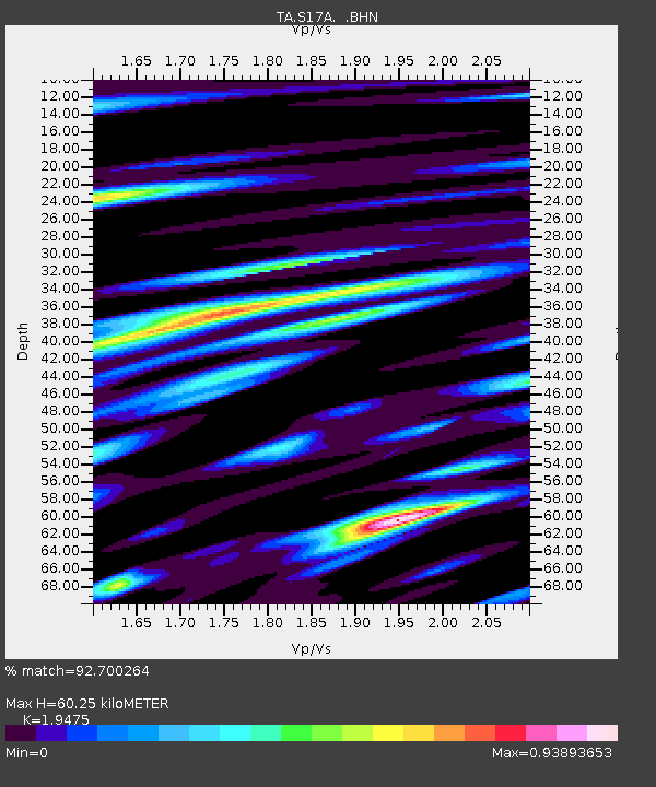
| Estimated Moho Depth: |
60.25 km |
| Estimated Crust Vp/Vs: |
1.95 |
| Assumed Crust Vp: |
6.247 km/s |
| Estimated Crust Vs: |
3.207 km/s |
| Estimated Crust Poisson's Ratio: |
0.32 |
|
| Radial Match: |
92.700264 % |
| Radial Bump: |
400 |
| Transverse Match: |
93.6438 % |
| Transverse Bump: |
400 |
| SOD ConfigId: |
2504 |
| Insert Time: |
2010-03-06 14:49:16.102 +0000 |
| GWidth: |
2.5 |
| Max Bumps: |
400 |
| Tol: |
0.001 |
|
Signal To Noise
| Channel | StoN | STA | LTA |
| TA:S17A: :BHN:20080705T02:21:06.948994Z | 60.740288 | 8.199565E-6 | 1.3499384E-7 |
| TA:S17A: :BHE:20080705T02:21:06.948994Z | 20.93128 | 1.9426789E-6 | 9.2812236E-8 |
| TA:S17A: :BHZ:20080705T02:21:06.948994Z | 17.935152 | 1.9335964E-6 | 1.0781042E-7 |
| Arrivals |
| Ps | 9.5 SECOND |
| PpPs | 27 SECOND |
| PsPs/PpSs | 37 SECOND |


