You are here: Home > Network List > IU - Global Seismograph Network (GSN - IRIS/USGS) Stations List
> Station PMG Port Moresby, New Guinea > Earthquake Result Viewer
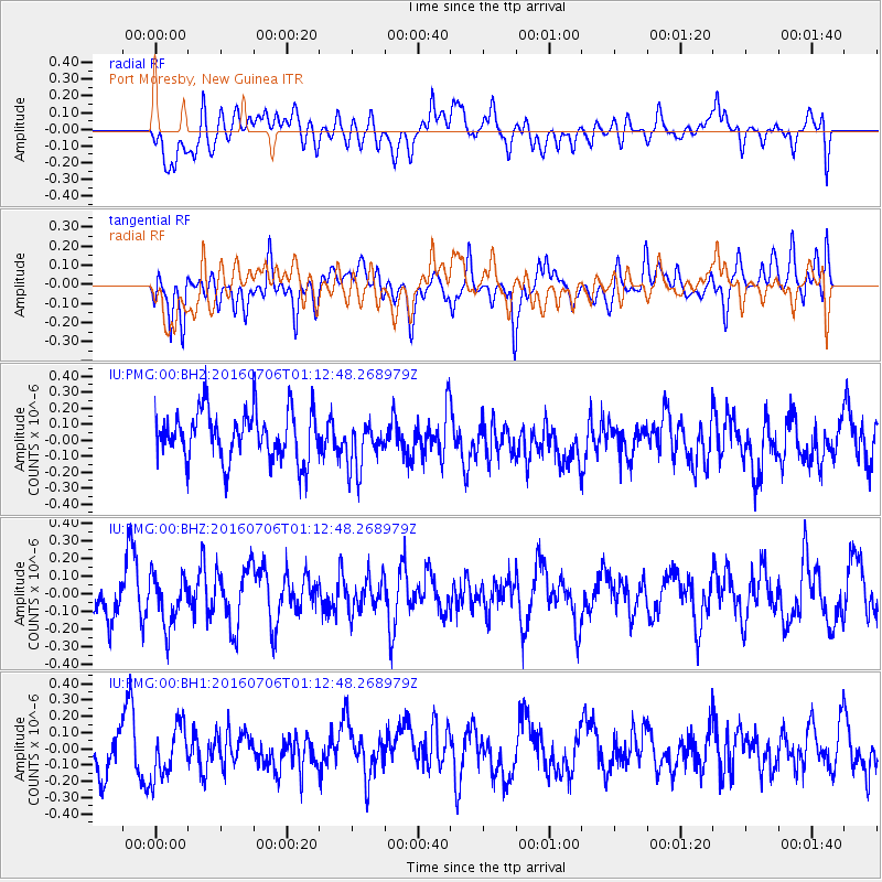
PMG Port Moresby, New Guinea - Earthquake Result Viewer
*The percent match for this event was below the threshold and hence no stack was calculated.
| Earthquake location: |
Pacific-Antarctic Ridge |
| Earthquake latitude/longitude: |
-56.8/-142.1 |
| Earthquake time(UTC): |
2016/07/06 (188) 01:01:57 GMT |
| Earthquake Depth: |
10 km |
| Earthquake Magnitude: |
5.8 MWW, 5.7 MWB, 5.8 MWC, 5.9 MWC |
| Earthquake Catalog/Contributor: |
NEIC PDE/NEIC COMCAT |
|
| Network: |
IU Global Seismograph Network (GSN - IRIS/USGS) |
| Station: |
PMG Port Moresby, New Guinea |
| Lat/Lon: |
9.40 S/147.16 E |
| Elevation: |
90 m |
|
| Distance: |
71.7 deg |
| Az: |
281.055 deg |
| Baz: |
146.796 deg |
| Ray Param: |
$rayparam |
*The percent match for this event was below the threshold and hence was not used in the summary stack. |
|
| Radial Match: |
52.339043 % |
| Radial Bump: |
400 |
| Transverse Match: |
57.85635 % |
| Transverse Bump: |
400 |
| SOD ConfigId: |
1634031 |
| Insert Time: |
2016-07-20 01:03:06.660 +0000 |
| GWidth: |
2.5 |
| Max Bumps: |
400 |
| Tol: |
0.001 |
|
Signal To Noise
| Channel | StoN | STA | LTA |
| IU:PMG:00:BHZ:20160706T01:12:48.268979Z | 0.8601208 | 1.3957295E-7 | 1.6227135E-7 |
| IU:PMG:00:BH1:20160706T01:12:48.268979Z | 1.189557 | 1.5986933E-7 | 1.3439401E-7 |
| IU:PMG:00:BH2:20160706T01:12:48.268979Z | 1.0072055 | 1.5625778E-7 | 1.5513992E-7 |
| Arrivals |
| Ps | |
| PpPs | |
| PsPs/PpSs | |


