You are here: Home > Network List > N4 - Central and EAstern US Network Stations List
> Station Q51A Peebles, OH, USA > Earthquake Result Viewer
Q51A Peebles, OH, USA - Earthquake Result Viewer
| Earthquake location: |
Fox Islands, Aleutian Islands |
| Earthquake latitude/longitude: |
52.3/-171.2 |
| Earthquake time(UTC): |
2018/08/25 (237) 16:50:04 GMT |
| Earthquake Depth: |
35 km |
| Earthquake Magnitude: |
5.5 Ml |
| Earthquake Catalog/Contributor: |
NEIC PDE/us |
|
| Network: |
N4 Central and EAstern US Network |
| Station: |
Q51A Peebles, OH, USA |
| Lat/Lon: |
39.03 N/83.35 W |
| Elevation: |
362 m |
|
| Distance: |
59.1 deg |
| Az: |
65.055 deg |
| Baz: |
314.354 deg |
| Ray Param: |
0.062319934 |
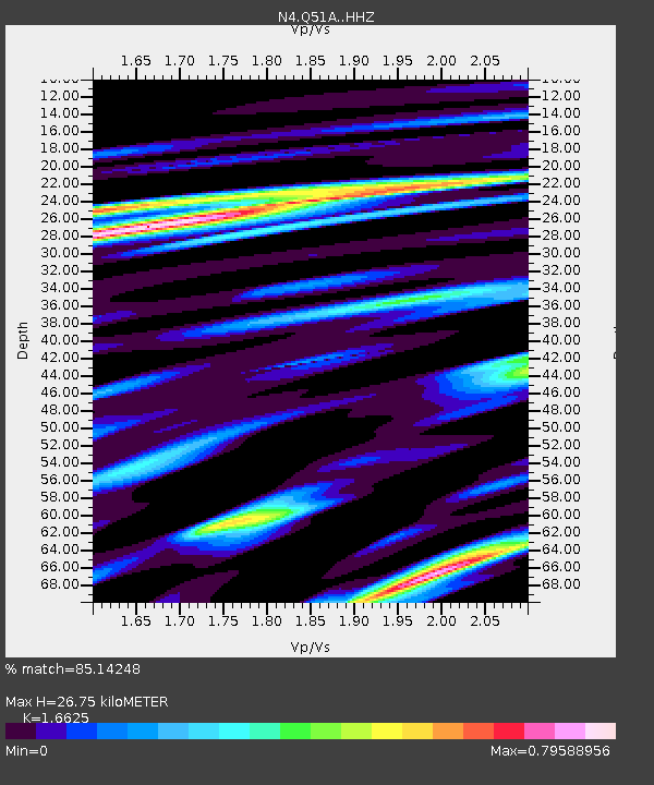
| Estimated Moho Depth: |
26.75 km |
| Estimated Crust Vp/Vs: |
1.66 |
| Assumed Crust Vp: |
6.232 km/s |
| Estimated Crust Vs: |
3.748 km/s |
| Estimated Crust Poisson's Ratio: |
0.22 |
|
| Radial Match: |
85.14248 % |
| Radial Bump: |
356 |
| Transverse Match: |
68.62895 % |
| Transverse Bump: |
400 |
| SOD ConfigId: |
13570011 |
| Insert Time: |
2019-05-01 00:10:06.862 +0000 |
| GWidth: |
2.5 |
| Max Bumps: |
400 |
| Tol: |
0.001 |
|

Signal To Noise
| Channel | StoN | STA | LTA |
| N4:Q51A: :HHZ:20180825T16:59:29.520012Z | 9.157528 | 8.856934E-7 | 9.671752E-8 |
| N4:Q51A: :HHN:20180825T16:59:29.520012Z | 3.0788198 | 3.8405318E-7 | 1.247404E-7 |
| N4:Q51A: :HHE:20180825T16:59:29.520012Z | 4.36431 | 4.0171187E-7 | 9.2044765E-8 |
| Arrivals |
| Ps | 3.0 SECOND |
| PpPs | 11 SECOND |
| PsPs/PpSs | 14 SECOND |


