You are here: Home > Network List > TA - USArray Transportable Network (new EarthScope stations) Stations List
> Station S17A Black Ridge (BLM), Bullfrog Basin, UT, USA > Earthquake Result Viewer
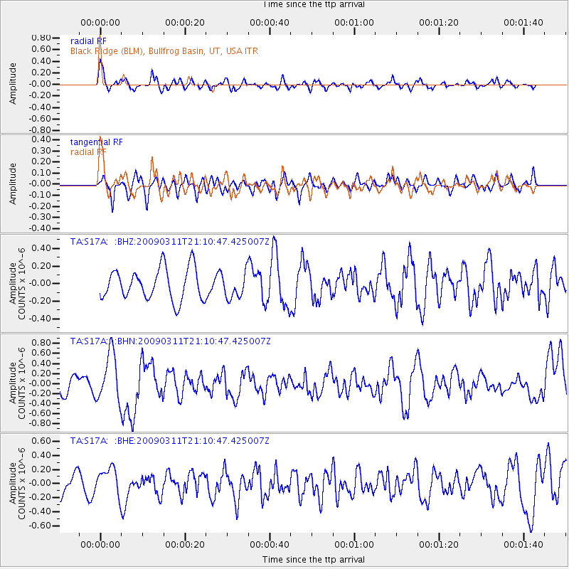
S17A Black Ridge (BLM), Bullfrog Basin, UT, USA - Earthquake Result Viewer
*The percent match for this event was below the threshold and hence no stack was calculated.
| Earthquake location: |
Costa Rica |
| Earthquake latitude/longitude: |
8.5/-83.2 |
| Earthquake time(UTC): |
2009/03/11 (070) 21:03:58 GMT |
| Earthquake Depth: |
17 km |
| Earthquake Magnitude: |
5.7 MB, 5.6 MS, 5.9 MW, 5.8 MW |
| Earthquake Catalog/Contributor: |
WHDF/NEIC |
|
| Network: |
TA USArray Transportable Network (new EarthScope stations) |
| Station: |
S17A Black Ridge (BLM), Bullfrog Basin, UT, USA |
| Lat/Lon: |
37.64 N/110.80 W |
| Elevation: |
1373 m |
|
| Distance: |
38.3 deg |
| Az: |
323.569 deg |
| Baz: |
132.275 deg |
| Ray Param: |
$rayparam |
*The percent match for this event was below the threshold and hence was not used in the summary stack. |
|
| Radial Match: |
66.4958 % |
| Radial Bump: |
395 |
| Transverse Match: |
58.574528 % |
| Transverse Bump: |
400 |
| SOD ConfigId: |
2658 |
| Insert Time: |
2010-03-06 14:50:06.036 +0000 |
| GWidth: |
2.5 |
| Max Bumps: |
400 |
| Tol: |
0.001 |
|
Signal To Noise
| Channel | StoN | STA | LTA |
| TA:S17A: :BHN:20090311T21:10:47.425007Z | 3.1376734 | 4.911475E-7 | 1.5653238E-7 |
| TA:S17A: :BHE:20090311T21:10:47.425007Z | 0.97295386 | 2.0168113E-7 | 2.0728746E-7 |
| TA:S17A: :BHZ:20090311T21:10:47.425007Z | 0.82123464 | 1.4706269E-7 | 1.7907512E-7 |
| Arrivals |
| Ps | |
| PpPs | |
| PsPs/PpSs | |


