You are here: Home > Network List > TA - USArray Transportable Network (new EarthScope stations) Stations List
> Station S17A Black Ridge (BLM), Bullfrog Basin, UT, USA > Earthquake Result Viewer
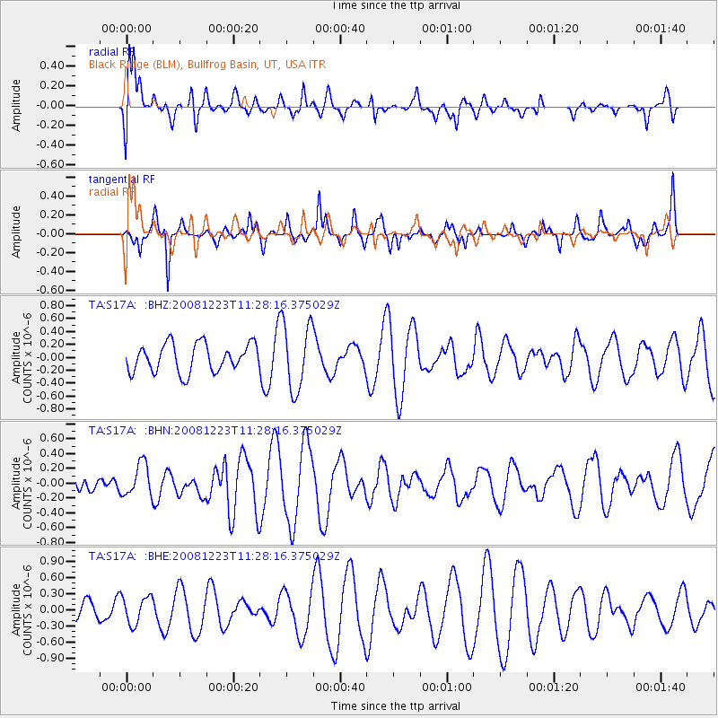
S17A Black Ridge (BLM), Bullfrog Basin, UT, USA - Earthquake Result Viewer
*The percent match for this event was below the threshold and hence no stack was calculated.
| Earthquake location: |
Solomon Islands |
| Earthquake latitude/longitude: |
-6.4/154.9 |
| Earthquake time(UTC): |
2008/12/23 (358) 11:15:18 GMT |
| Earthquake Depth: |
32 km |
| Earthquake Magnitude: |
5.8 MB, 5.6 MS, 5.9 MW, 5.9 MW |
| Earthquake Catalog/Contributor: |
WHDF/NEIC |
|
| Network: |
TA USArray Transportable Network (new EarthScope stations) |
| Station: |
S17A Black Ridge (BLM), Bullfrog Basin, UT, USA |
| Lat/Lon: |
37.64 N/110.80 W |
| Elevation: |
1373 m |
|
| Distance: |
97.2 deg |
| Az: |
52.941 deg |
| Baz: |
267.539 deg |
| Ray Param: |
$rayparam |
*The percent match for this event was below the threshold and hence was not used in the summary stack. |
|
| Radial Match: |
66.40191 % |
| Radial Bump: |
400 |
| Transverse Match: |
74.51963 % |
| Transverse Bump: |
368 |
| SOD ConfigId: |
2658 |
| Insert Time: |
2010-03-06 14:50:08.920 +0000 |
| GWidth: |
2.5 |
| Max Bumps: |
400 |
| Tol: |
0.001 |
|
Signal To Noise
| Channel | StoN | STA | LTA |
| TA:S17A: :BHN:20081223T11:28:16.375029Z | 1.317008 | 2.2473526E-7 | 1.7064077E-7 |
| TA:S17A: :BHE:20081223T11:28:16.375029Z | 0.883487 | 2.5621208E-7 | 2.9000097E-7 |
| TA:S17A: :BHZ:20081223T11:28:16.375029Z | 2.3859994 | 5.1845E-7 | 2.1728842E-7 |
| Arrivals |
| Ps | |
| PpPs | |
| PsPs/PpSs | |


