You are here: Home > Network List > TA - USArray Transportable Network (new EarthScope stations) Stations List
> Station S17A Black Ridge (BLM), Bullfrog Basin, UT, USA > Earthquake Result Viewer
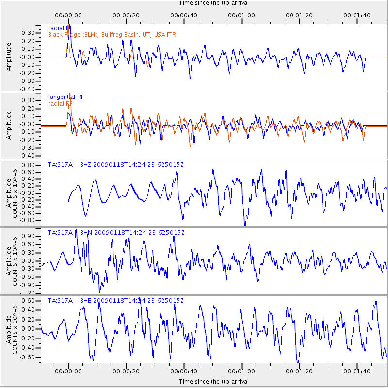
S17A Black Ridge (BLM), Bullfrog Basin, UT, USA - Earthquake Result Viewer
*The percent match for this event was below the threshold and hence no stack was calculated.
| Earthquake location: |
Kermadec Islands, New Zealand |
| Earthquake latitude/longitude: |
-30.2/-178.0 |
| Earthquake time(UTC): |
2009/01/18 (018) 14:11:48 GMT |
| Earthquake Depth: |
33 km |
| Earthquake Magnitude: |
6.0 MB, 6.1 MS, 6.4 MW, 6.4 MW |
| Earthquake Catalog/Contributor: |
WHDF/NEIC |
|
| Network: |
TA USArray Transportable Network (new EarthScope stations) |
| Station: |
S17A Black Ridge (BLM), Bullfrog Basin, UT, USA |
| Lat/Lon: |
37.64 N/110.80 W |
| Elevation: |
1373 m |
|
| Distance: |
92.1 deg |
| Az: |
47.063 deg |
| Baz: |
232.974 deg |
| Ray Param: |
$rayparam |
*The percent match for this event was below the threshold and hence was not used in the summary stack. |
|
| Radial Match: |
60.973278 % |
| Radial Bump: |
400 |
| Transverse Match: |
37.277054 % |
| Transverse Bump: |
358 |
| SOD ConfigId: |
2658 |
| Insert Time: |
2010-03-06 14:50:09.575 +0000 |
| GWidth: |
2.5 |
| Max Bumps: |
400 |
| Tol: |
0.001 |
|
Signal To Noise
| Channel | StoN | STA | LTA |
| TA:S17A: :BHN:20090118T14:24:23.625015Z | 2.9418652 | 4.436743E-7 | 1.5081395E-7 |
| TA:S17A: :BHE:20090118T14:24:23.625015Z | 0.76546085 | 2.2902861E-7 | 2.9920358E-7 |
| TA:S17A: :BHZ:20090118T14:24:23.625015Z | 0.66646695 | 1.4936502E-7 | 2.2411467E-7 |
| Arrivals |
| Ps | |
| PpPs | |
| PsPs/PpSs | |


