You are here: Home > Network List > TA - USArray Transportable Network (new EarthScope stations) Stations List
> Station S17A Black Ridge (BLM), Bullfrog Basin, UT, USA > Earthquake Result Viewer
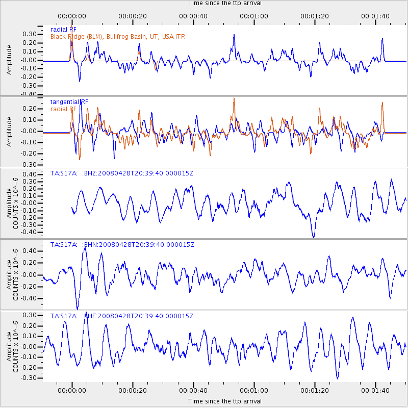
S17A Black Ridge (BLM), Bullfrog Basin, UT, USA - Earthquake Result Viewer
*The percent match for this event was below the threshold and hence no stack was calculated.
| Earthquake location: |
Loyalty Islands |
| Earthquake latitude/longitude: |
-20.2/168.8 |
| Earthquake time(UTC): |
2008/04/28 (119) 20:26:53 GMT |
| Earthquake Depth: |
35 km |
| Earthquake Magnitude: |
5.8 MB, 5.7 MS, 6.1 MW, 6.0 MW |
| Earthquake Catalog/Contributor: |
WHDF/NEIC |
|
| Network: |
TA USArray Transportable Network (new EarthScope stations) |
| Station: |
S17A Black Ridge (BLM), Bullfrog Basin, UT, USA |
| Lat/Lon: |
37.64 N/110.80 W |
| Elevation: |
1373 m |
|
| Distance: |
94.8 deg |
| Az: |
51.769 deg |
| Baz: |
248.297 deg |
| Ray Param: |
$rayparam |
*The percent match for this event was below the threshold and hence was not used in the summary stack. |
|
| Radial Match: |
45.975605 % |
| Radial Bump: |
284 |
| Transverse Match: |
55.031788 % |
| Transverse Bump: |
365 |
| SOD ConfigId: |
2504 |
| Insert Time: |
2010-03-06 14:50:21.474 +0000 |
| GWidth: |
2.5 |
| Max Bumps: |
400 |
| Tol: |
0.001 |
|
Signal To Noise
| Channel | StoN | STA | LTA |
| TA:S17A: :BHN:20080428T20:39:40.000015Z | 3.0056722 | 3.1763201E-7 | 1.0567753E-7 |
| TA:S17A: :BHE:20080428T20:39:40.000015Z | 1.726577 | 1.5768336E-7 | 9.132715E-8 |
| TA:S17A: :BHZ:20080428T20:39:40.000015Z | 1.119088 | 1.3719145E-7 | 1.2259218E-7 |
| Arrivals |
| Ps | |
| PpPs | |
| PsPs/PpSs | |


