You are here: Home > Network List > TA - USArray Transportable Network (new EarthScope stations) Stations List
> Station S17A Black Ridge (BLM), Bullfrog Basin, UT, USA > Earthquake Result Viewer
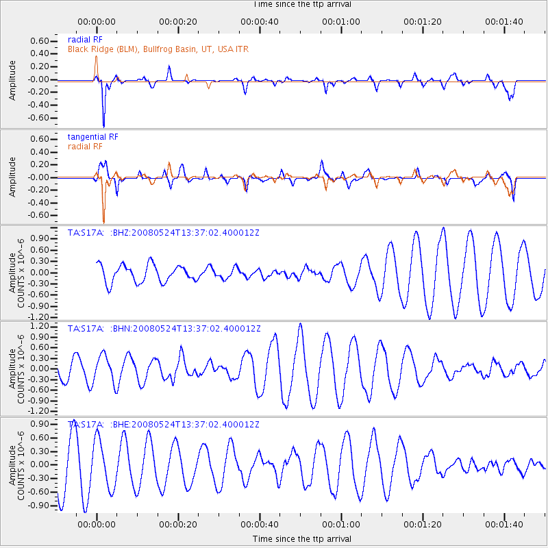
S17A Black Ridge (BLM), Bullfrog Basin, UT, USA - Earthquake Result Viewer
*The percent match for this event was below the threshold and hence no stack was calculated.
| Earthquake location: |
Solomon Islands |
| Earthquake latitude/longitude: |
-7.2/156.1 |
| Earthquake time(UTC): |
2008/05/24 (145) 13:24:05 GMT |
| Earthquake Depth: |
29 km |
| Earthquake Magnitude: |
5.8 MB, 5.5 MS, 5.9 MW, 5.8 MW |
| Earthquake Catalog/Contributor: |
WHDF/NEIC |
|
| Network: |
TA USArray Transportable Network (new EarthScope stations) |
| Station: |
S17A Black Ridge (BLM), Bullfrog Basin, UT, USA |
| Lat/Lon: |
37.64 N/110.80 W |
| Elevation: |
1373 m |
|
| Distance: |
96.8 deg |
| Az: |
52.971 deg |
| Baz: |
266.209 deg |
| Ray Param: |
$rayparam |
*The percent match for this event was below the threshold and hence was not used in the summary stack. |
|
| Radial Match: |
77.88132 % |
| Radial Bump: |
327 |
| Transverse Match: |
61.81356 % |
| Transverse Bump: |
400 |
| SOD ConfigId: |
2504 |
| Insert Time: |
2010-03-06 14:50:24.789 +0000 |
| GWidth: |
2.5 |
| Max Bumps: |
400 |
| Tol: |
0.001 |
|
Signal To Noise
| Channel | StoN | STA | LTA |
| TA:S17A: :BHN:20080524T13:37:02.400012Z | 1.6844523 | 3.8473576E-7 | 2.2840408E-7 |
| TA:S17A: :BHE:20080524T13:37:02.400012Z | 0.97648454 | 5.317528E-7 | 5.4455836E-7 |
| TA:S17A: :BHZ:20080524T13:37:02.400012Z | 0.5954336 | 1.3603989E-7 | 2.2847196E-7 |
| Arrivals |
| Ps | |
| PpPs | |
| PsPs/PpSs | |


