You are here: Home > Network List > TA - USArray Transportable Network (new EarthScope stations) Stations List
> Station S17A Black Ridge (BLM), Bullfrog Basin, UT, USA > Earthquake Result Viewer
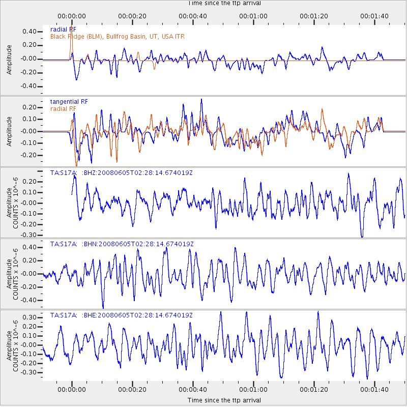
S17A Black Ridge (BLM), Bullfrog Basin, UT, USA - Earthquake Result Viewer
*The percent match for this event was below the threshold and hence no stack was calculated.
| Earthquake location: |
West Chile Rise |
| Earthquake latitude/longitude: |
-38.8/-91.6 |
| Earthquake time(UTC): |
2008/06/05 (157) 02:16:46 GMT |
| Earthquake Depth: |
10 km |
| Earthquake Magnitude: |
5.6 MS, 5.4 MB, 6.0 MW, 6.0 MW |
| Earthquake Catalog/Contributor: |
WHDF/NEIC |
|
| Network: |
TA USArray Transportable Network (new EarthScope stations) |
| Station: |
S17A Black Ridge (BLM), Bullfrog Basin, UT, USA |
| Lat/Lon: |
37.64 N/110.80 W |
| Elevation: |
1373 m |
|
| Distance: |
78.1 deg |
| Az: |
344.543 deg |
| Baz: |
164.802 deg |
| Ray Param: |
$rayparam |
*The percent match for this event was below the threshold and hence was not used in the summary stack. |
|
| Radial Match: |
57.089092 % |
| Radial Bump: |
400 |
| Transverse Match: |
60.306873 % |
| Transverse Bump: |
400 |
| SOD ConfigId: |
2504 |
| Insert Time: |
2010-03-06 14:50:26.167 +0000 |
| GWidth: |
2.5 |
| Max Bumps: |
400 |
| Tol: |
0.001 |
|
Signal To Noise
| Channel | StoN | STA | LTA |
| TA:S17A: :BHN:20080605T02:28:14.674019Z | 1.5434661 | 1.0250785E-7 | 6.641406E-8 |
| TA:S17A: :BHE:20080605T02:28:14.674019Z | 0.9934382 | 1.0976877E-7 | 1.1049381E-7 |
| TA:S17A: :BHZ:20080605T02:28:14.674019Z | 0.66441274 | 6.066054E-8 | 9.1299476E-8 |
| Arrivals |
| Ps | |
| PpPs | |
| PsPs/PpSs | |


