You are here: Home > Network List > AK - Alaska Regional Network Stations List
> Station RIDG Independent Ridge > Earthquake Result Viewer
RIDG Independent Ridge - Earthquake Result Viewer
| Earthquake location: |
Western Iran |
| Earthquake latitude/longitude: |
34.7/46.2 |
| Earthquake time(UTC): |
2018/08/25 (237) 22:13:26 GMT |
| Earthquake Depth: |
10 km |
| Earthquake Magnitude: |
6.1 Mww |
| Earthquake Catalog/Contributor: |
NEIC PDE/us |
|
| Network: |
AK Alaska Regional Network |
| Station: |
RIDG Independent Ridge |
| Lat/Lon: |
63.74 N/144.84 W |
| Elevation: |
888 m |
|
| Distance: |
81.5 deg |
| Az: |
4.947 deg |
| Baz: |
350.806 deg |
| Ray Param: |
0.047525212 |
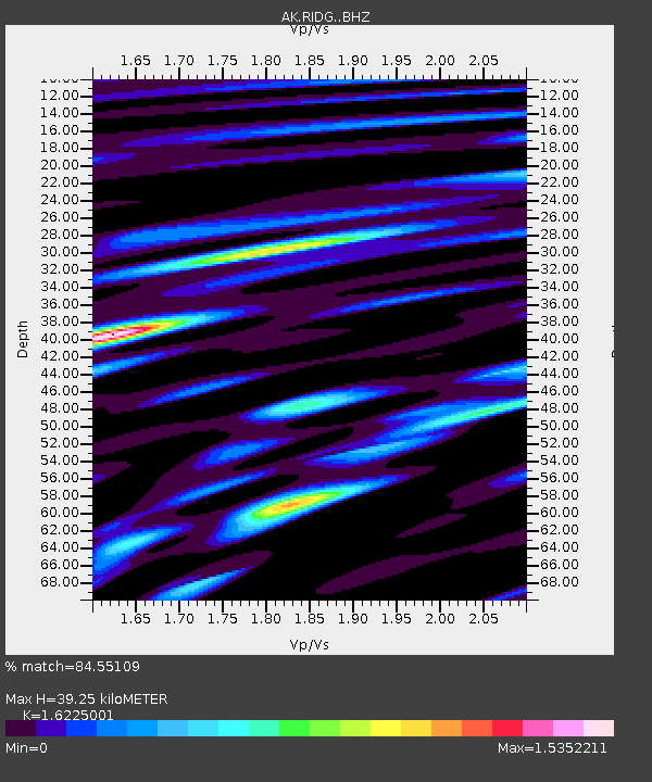
| Estimated Moho Depth: |
39.25 km |
| Estimated Crust Vp/Vs: |
1.62 |
| Assumed Crust Vp: |
6.566 km/s |
| Estimated Crust Vs: |
4.047 km/s |
| Estimated Crust Poisson's Ratio: |
0.19 |
|
| Radial Match: |
84.55109 % |
| Radial Bump: |
400 |
| Transverse Match: |
69.806114 % |
| Transverse Bump: |
400 |
| SOD ConfigId: |
13570011 |
| Insert Time: |
2019-05-01 00:19:37.419 +0000 |
| GWidth: |
2.5 |
| Max Bumps: |
400 |
| Tol: |
0.001 |
|

Signal To Noise
| Channel | StoN | STA | LTA |
| AK:RIDG: :BHZ:20180825T22:25:12.087979Z | 5.042914 | 3.1602576E-7 | 6.26673E-8 |
| AK:RIDG: :BHN:20180825T22:25:12.087979Z | 1.7572075 | 1.4722403E-7 | 8.378294E-8 |
| AK:RIDG: :BHE:20180825T22:25:12.087979Z | 1.8550322 | 1.760806E-7 | 9.492051E-8 |
| Arrivals |
| Ps | 3.8 SECOND |
| PpPs | 15 SECOND |
| PsPs/PpSs | 19 SECOND |


