You are here: Home > Network List > TA - USArray Transportable Network (new EarthScope stations) Stations List
> Station T17A Navajo Res., Navajo Mountain, AZ, USA > Earthquake Result Viewer
T17A Navajo Res., Navajo Mountain, AZ, USA - Earthquake Result Viewer

| Earthquake location: |
Off East Coast Of Honshu, Japan |
| Earthquake latitude/longitude: |
37.6/142.2 |
| Earthquake time(UTC): |
2008/07/19 (201) 02:39:28 GMT |
| Earthquake Depth: |
22 km |
| Earthquake Magnitude: |
6.2 MB, 7.0 MS, 7.0 MW, 6.9 MW |
| Earthquake Catalog/Contributor: |
WHDF/NEIC |
|
| Network: |
TA USArray Transportable Network (new EarthScope stations) |
| Station: |
T17A Navajo Res., Navajo Mountain, AZ, USA |
| Lat/Lon: |
37.00 N/110.80 W |
| Elevation: |
1876 m |
|
| Distance: |
79.8 deg |
| Az: |
51.087 deg |
| Baz: |
309.428 deg |
| Ray Param: |
0.048719265 |
| Estimated Moho Depth: |
51.25 km |
| Estimated Crust Vp/Vs: |
2.07 |
| Assumed Crust Vp: |
6.247 km/s |
| Estimated Crust Vs: |
3.021 km/s |
| Estimated Crust Poisson's Ratio: |
0.35 |
|
| Radial Match: |
95.42807 % |
| Radial Bump: |
400 |
| Transverse Match: |
80.601204 % |
| Transverse Bump: |
400 |
| SOD ConfigId: |
2504 |
| Insert Time: |
2010-03-06 14:50:51.984 +0000 |
| GWidth: |
2.5 |
| Max Bumps: |
400 |
| Tol: |
0.001 |
|
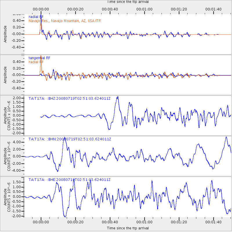
Signal To Noise
| Channel | StoN | STA | LTA |
| TA:T17A: :BHN:20080719T02:51:03.624011Z | 3.32667 | 3.1376373E-7 | 9.431766E-8 |
| TA:T17A: :BHE:20080719T02:51:03.624011Z | 1.3460177 | 1.0313425E-7 | 7.662176E-8 |
| TA:T17A: :BHZ:20080719T02:51:03.624011Z | 1.526231 | 1.3020667E-7 | 8.531255E-8 |
| Arrivals |
| Ps | 9.0 SECOND |
| PpPs | 25 SECOND |
| PsPs/PpSs | 34 SECOND |


