You are here: Home > Network List > TA - USArray Transportable Network (new EarthScope stations) Stations List
> Station T17A Navajo Res., Navajo Mountain, AZ, USA > Earthquake Result Viewer
T17A Navajo Res., Navajo Mountain, AZ, USA - Earthquake Result Viewer
| Earthquake location: |
Central Mid-Atlantic Ridge |
| Earthquake latitude/longitude: |
8.1/-38.7 |
| Earthquake time(UTC): |
2008/09/10 (254) 13:08:14 GMT |
| Earthquake Depth: |
10 km |
| Earthquake Magnitude: |
6.3 MB, 6.5 MS, 6.6 MW, 6.6 MW |
| Earthquake Catalog/Contributor: |
WHDF/NEIC |
|
| Network: |
TA USArray Transportable Network (new EarthScope stations) |
| Station: |
T17A Navajo Res., Navajo Mountain, AZ, USA |
| Lat/Lon: |
37.00 N/110.80 W |
| Elevation: |
1876 m |
|
| Distance: |
70.9 deg |
| Az: |
306.265 deg |
| Baz: |
94.282 deg |
| Ray Param: |
0.054693095 |
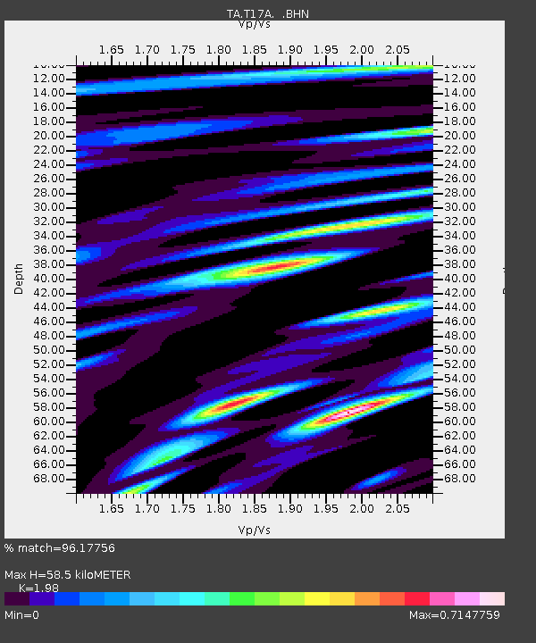
| Estimated Moho Depth: |
58.5 km |
| Estimated Crust Vp/Vs: |
1.98 |
| Assumed Crust Vp: |
6.247 km/s |
| Estimated Crust Vs: |
3.155 km/s |
| Estimated Crust Poisson's Ratio: |
0.33 |
|
| Radial Match: |
96.17756 % |
| Radial Bump: |
400 |
| Transverse Match: |
87.32221 % |
| Transverse Bump: |
400 |
| SOD ConfigId: |
2560 |
| Insert Time: |
2010-03-06 14:51:01.555 +0000 |
| GWidth: |
2.5 |
| Max Bumps: |
400 |
| Tol: |
0.001 |
|
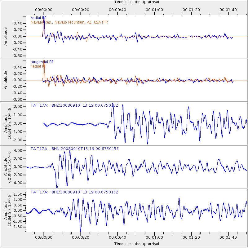
Signal To Noise
| Channel | StoN | STA | LTA |
| TA:T17A: :BHN:20080910T13:19:00.675015Z | 3.2641644 | 3.6081124E-7 | 1.10537094E-7 |
| TA:T17A: :BHE:20080910T13:19:00.675015Z | 0.9164622 | 1.186997E-7 | 1.2951948E-7 |
| TA:T17A: :BHZ:20080910T13:19:00.675015Z | 1.359419 | 1.3071922E-7 | 9.6158146E-8 |
| Arrivals |
| Ps | 9.5 SECOND |
| PpPs | 27 SECOND |
| PsPs/PpSs | 37 SECOND |


