You are here: Home > Network List > TA - USArray Transportable Network (new EarthScope stations) Stations List
> Station T17A Navajo Res., Navajo Mountain, AZ, USA > Earthquake Result Viewer
T17A Navajo Res., Navajo Mountain, AZ, USA - Earthquake Result Viewer
| Earthquake location: |
Kermadec Islands, New Zealand |
| Earthquake latitude/longitude: |
-29.8/-177.7 |
| Earthquake time(UTC): |
2008/09/29 (273) 15:19:31 GMT |
| Earthquake Depth: |
36 km |
| Earthquake Magnitude: |
6.5 MB, 6.7 MS, 7.0 MW, 7.0 MW |
| Earthquake Catalog/Contributor: |
WHDF/NEIC |
|
| Network: |
TA USArray Transportable Network (new EarthScope stations) |
| Station: |
T17A Navajo Res., Navajo Mountain, AZ, USA |
| Lat/Lon: |
37.00 N/110.80 W |
| Elevation: |
1876 m |
|
| Distance: |
91.3 deg |
| Az: |
47.433 deg |
| Baz: |
233.124 deg |
| Ray Param: |
0.041608084 |
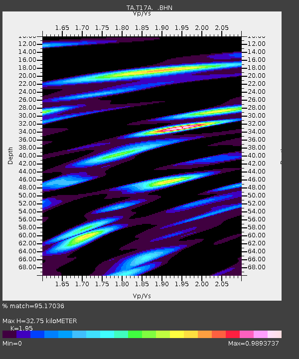
| Estimated Moho Depth: |
32.75 km |
| Estimated Crust Vp/Vs: |
1.95 |
| Assumed Crust Vp: |
6.247 km/s |
| Estimated Crust Vs: |
3.203 km/s |
| Estimated Crust Poisson's Ratio: |
0.32 |
|
| Radial Match: |
95.17036 % |
| Radial Bump: |
400 |
| Transverse Match: |
88.456726 % |
| Transverse Bump: |
400 |
| SOD ConfigId: |
2560 |
| Insert Time: |
2010-03-06 14:51:09.993 +0000 |
| GWidth: |
2.5 |
| Max Bumps: |
400 |
| Tol: |
0.001 |
|
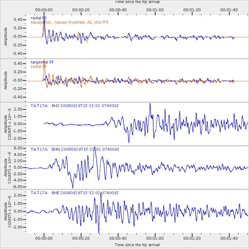
Signal To Noise
| Channel | StoN | STA | LTA |
| TA:T17A: :BHN:20080929T15:32:02.074009Z | 5.0772476 | 4.3808066E-7 | 8.62831E-8 |
| TA:T17A: :BHE:20080929T15:32:02.074009Z | 1.2744675 | 1.02396555E-7 | 8.034458E-8 |
| TA:T17A: :BHZ:20080929T15:32:02.074009Z | 1.3790674 | 1.3549169E-7 | 9.824878E-8 |
| Arrivals |
| Ps | 5.1 SECOND |
| PpPs | 15 SECOND |
| PsPs/PpSs | 20 SECOND |


