You are here: Home > Network List > GB - Great Britain Seismograph Network Stations List
> Station WLF1 LLYNFAES, WALES > Earthquake Result Viewer
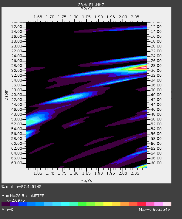
WLF1 LLYNFAES, WALES - Earthquake Result Viewer
| Earthquake location: |
Western Iran |
| Earthquake latitude/longitude: |
34.7/46.2 |
| Earthquake time(UTC): |
2018/08/25 (237) 22:13:26 GMT |
| Earthquake Depth: |
10 km |
| Earthquake Magnitude: |
6.1 Mww |
| Earthquake Catalog/Contributor: |
NEIC PDE/us |
|
| Network: |
GB Great Britain Seismograph Network |
| Station: |
WLF1 LLYNFAES, WALES |
| Lat/Lon: |
53.29 N/4.40 W |
| Elevation: |
66 m |
|
| Distance: |
39.9 deg |
| Az: |
313.7 deg |
| Baz: |
97.009 deg |
| Ray Param: |
0.074697636 |
| Estimated Moho Depth: |
28.5 km |
| Estimated Crust Vp/Vs: |
2.10 |
| Assumed Crust Vp: |
6.182 km/s |
| Estimated Crust Vs: |
2.947 km/s |
| Estimated Crust Poisson's Ratio: |
0.35 |
|
| Radial Match: |
87.445145 % |
| Radial Bump: |
327 |
| Transverse Match: |
61.2773 % |
| Transverse Bump: |
400 |
| SOD ConfigId: |
13570011 |
| Insert Time: |
2019-05-01 00:21:39.894 +0000 |
| GWidth: |
2.5 |
| Max Bumps: |
400 |
| Tol: |
0.001 |
|

Signal To Noise
| Channel | StoN | STA | LTA |
| GB:WLF1: :HHZ:20180825T22:20:29.439999Z | 9.813478 | 5.012328E-6 | 5.1075955E-7 |
| GB:WLF1: :HHN:20180825T22:20:29.439999Z | 1.0930102 | 4.220275E-7 | 3.8611492E-7 |
| GB:WLF1: :HHE:20180825T22:20:29.439999Z | 10.061691 | 3.2001115E-6 | 3.1804908E-7 |
| Arrivals |
| Ps | 5.3 SECOND |
| PpPs | 14 SECOND |
| PsPs/PpSs | 19 SECOND |


