You are here: Home > Network List > TA - USArray Transportable Network (new EarthScope stations) Stations List
> Station T17A Navajo Res., Navajo Mountain, AZ, USA > Earthquake Result Viewer
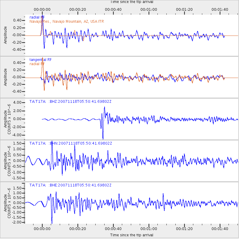
T17A Navajo Res., Navajo Mountain, AZ, USA - Earthquake Result Viewer

| Earthquake location: |
Jujuy Province, Argentina |
| Earthquake latitude/longitude: |
-22.6/-66.3 |
| Earthquake time(UTC): |
2007/11/18 (322) 05:40:12 GMT |
| Earthquake Depth: |
246 km |
| Earthquake Magnitude: |
5.7 MB, 6.0 MW, 6.0 MW |
| Earthquake Catalog/Contributor: |
WHDF/NEIC |
|
| Network: |
TA USArray Transportable Network (new EarthScope stations) |
| Station: |
T17A Navajo Res., Navajo Mountain, AZ, USA |
| Lat/Lon: |
37.00 N/110.80 W |
| Elevation: |
1876 m |
|
| Distance: |
72.6 deg |
| Az: |
324.004 deg |
| Baz: |
137.297 deg |
| Ray Param: |
0.05284553 |
| Estimated Moho Depth: |
23.75 km |
| Estimated Crust Vp/Vs: |
1.88 |
| Assumed Crust Vp: |
6.247 km/s |
| Estimated Crust Vs: |
3.331 km/s |
| Estimated Crust Poisson's Ratio: |
0.30 |
|
| Radial Match: |
82.17308 % |
| Radial Bump: |
400 |
| Transverse Match: |
57.64068 % |
| Transverse Bump: |
400 |
| SOD ConfigId: |
2564 |
| Insert Time: |
2010-03-06 14:51:27.687 +0000 |
| GWidth: |
2.5 |
| Max Bumps: |
400 |
| Tol: |
0.001 |
|
Signal To Noise
| Channel | StoN | STA | LTA |
| TA:T17A: :BHN:20071118T05:50:41.69802Z | 1.5562594 | 2.7782497E-7 | 1.7852099E-7 |
| TA:T17A: :BHE:20071118T05:50:41.69802Z | 2.3774638 | 4.0726925E-7 | 1.7130408E-7 |
| TA:T17A: :BHZ:20071118T05:50:41.69802Z | 11.463483 | 1.4411588E-6 | 1.2571736E-7 |
| Arrivals |
| Ps | 3.4 SECOND |
| PpPs | 11 SECOND |
| PsPs/PpSs | 14 SECOND |


