You are here: Home > Network List > TA - USArray Transportable Network (new EarthScope stations) Stations List
> Station F18K Selawik, AK, USA > Earthquake Result Viewer
F18K Selawik, AK, USA - Earthquake Result Viewer
| Earthquake location: |
Western Iran |
| Earthquake latitude/longitude: |
34.7/46.2 |
| Earthquake time(UTC): |
2018/08/25 (237) 22:13:26 GMT |
| Earthquake Depth: |
10 km |
| Earthquake Magnitude: |
6.1 Mww |
| Earthquake Catalog/Contributor: |
NEIC PDE/us |
|
| Network: |
TA USArray Transportable Network (new EarthScope stations) |
| Station: |
F18K Selawik, AK, USA |
| Lat/Lon: |
66.60 N/159.65 W |
| Elevation: |
27 m |
|
| Distance: |
77.1 deg |
| Az: |
10.296 deg |
| Baz: |
338.357 deg |
| Ray Param: |
0.05053946 |
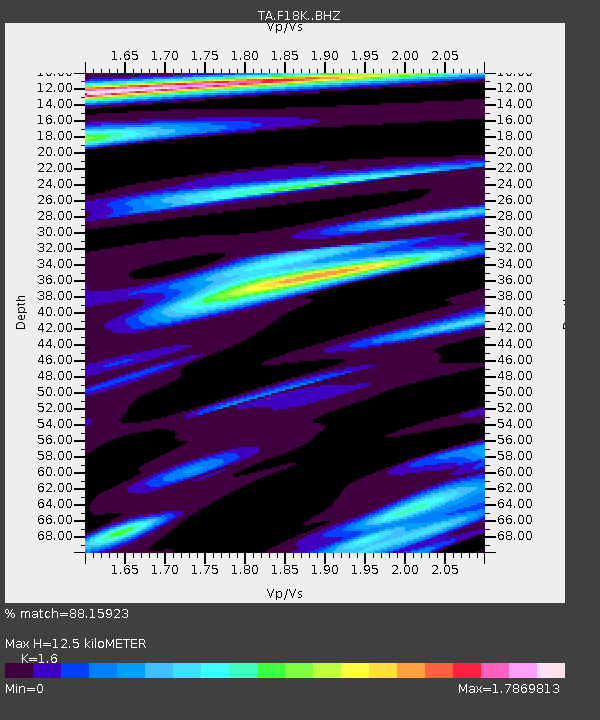
| Estimated Moho Depth: |
12.5 km |
| Estimated Crust Vp/Vs: |
1.60 |
| Assumed Crust Vp: |
6.577 km/s |
| Estimated Crust Vs: |
4.11 km/s |
| Estimated Crust Poisson's Ratio: |
0.18 |
|
| Radial Match: |
88.15923 % |
| Radial Bump: |
394 |
| Transverse Match: |
82.09945 % |
| Transverse Bump: |
384 |
| SOD ConfigId: |
13570011 |
| Insert Time: |
2019-05-01 00:24:29.409 +0000 |
| GWidth: |
2.5 |
| Max Bumps: |
400 |
| Tol: |
0.001 |
|

Signal To Noise
| Channel | StoN | STA | LTA |
| TA:F18K: :BHZ:20180825T22:24:48.125027Z | 11.966507 | 8.718814E-7 | 7.2860146E-8 |
| TA:F18K: :BHN:20180825T22:24:48.125027Z | 0.91449684 | 1.07052905E-7 | 1.17062086E-7 |
| TA:F18K: :BHE:20180825T22:24:48.125027Z | 0.9063102 | 1.0246813E-7 | 1.13060764E-7 |
| Arrivals |
| Ps | 1.2 SECOND |
| PpPs | 4.8 SECOND |
| PsPs/PpSs | 5.9 SECOND |


