You are here: Home > Network List > TA - USArray Transportable Network (new EarthScope stations) Stations List
> Station F19K Shaleruckik Mountain, AK, USA > Earthquake Result Viewer
F19K Shaleruckik Mountain, AK, USA - Earthquake Result Viewer
| Earthquake location: |
Western Iran |
| Earthquake latitude/longitude: |
34.7/46.2 |
| Earthquake time(UTC): |
2018/08/25 (237) 22:13:26 GMT |
| Earthquake Depth: |
10 km |
| Earthquake Magnitude: |
6.1 Mww |
| Earthquake Catalog/Contributor: |
NEIC PDE/us |
|
| Network: |
TA USArray Transportable Network (new EarthScope stations) |
| Station: |
F19K Shaleruckik Mountain, AK, USA |
| Lat/Lon: |
66.83 N/157.77 W |
| Elevation: |
161 m |
|
| Distance: |
77.2 deg |
| Az: |
9.495 deg |
| Baz: |
339.902 deg |
| Ray Param: |
0.05050805 |
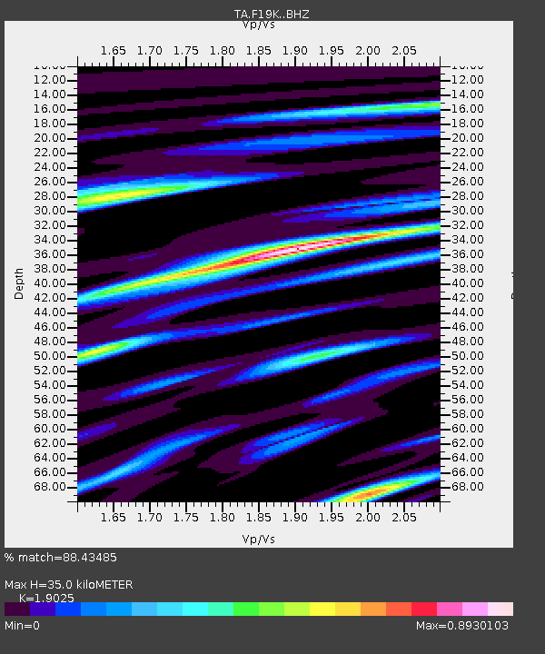
| Estimated Moho Depth: |
35.0 km |
| Estimated Crust Vp/Vs: |
1.90 |
| Assumed Crust Vp: |
6.577 km/s |
| Estimated Crust Vs: |
3.457 km/s |
| Estimated Crust Poisson's Ratio: |
0.31 |
|
| Radial Match: |
88.43485 % |
| Radial Bump: |
400 |
| Transverse Match: |
83.030876 % |
| Transverse Bump: |
400 |
| SOD ConfigId: |
13570011 |
| Insert Time: |
2019-05-01 00:24:30.246 +0000 |
| GWidth: |
2.5 |
| Max Bumps: |
400 |
| Tol: |
0.001 |
|

Signal To Noise
| Channel | StoN | STA | LTA |
| TA:F19K: :BHZ:20180825T22:24:48.375027Z | 7.3907056 | 5.998992E-7 | 8.1169404E-8 |
| TA:F19K: :BHN:20180825T22:24:48.375027Z | 5.455696 | 1.7059476E-7 | 3.126911E-8 |
| TA:F19K: :BHE:20180825T22:24:48.375027Z | 2.645692 | 1.14368376E-7 | 4.322815E-8 |
| Arrivals |
| Ps | 4.9 SECOND |
| PpPs | 15 SECOND |
| PsPs/PpSs | 20 SECOND |


