You are here: Home > Network List > TA - USArray Transportable Network (new EarthScope stations) Stations List
> Station H17K Granite Mountain, AK, USA > Earthquake Result Viewer
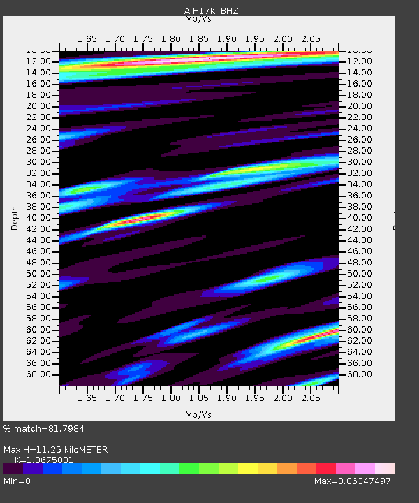
H17K Granite Mountain, AK, USA - Earthquake Result Viewer
| Earthquake location: |
Western Iran |
| Earthquake latitude/longitude: |
34.7/46.2 |
| Earthquake time(UTC): |
2018/08/25 (237) 22:13:26 GMT |
| Earthquake Depth: |
10 km |
| Earthquake Magnitude: |
6.1 Mww |
| Earthquake Catalog/Contributor: |
NEIC PDE/us |
|
| Network: |
TA USArray Transportable Network (new EarthScope stations) |
| Station: |
H17K Granite Mountain, AK, USA |
| Lat/Lon: |
64.94 N/159.91 W |
| Elevation: |
396 m |
|
| Distance: |
78.6 deg |
| Az: |
11.03 deg |
| Baz: |
338.273 deg |
| Ray Param: |
0.04951159 |
| Estimated Moho Depth: |
11.25 km |
| Estimated Crust Vp/Vs: |
1.87 |
| Assumed Crust Vp: |
6.1 km/s |
| Estimated Crust Vs: |
3.266 km/s |
| Estimated Crust Poisson's Ratio: |
0.30 |
|
| Radial Match: |
81.7984 % |
| Radial Bump: |
400 |
| Transverse Match: |
74.85573 % |
| Transverse Bump: |
400 |
| SOD ConfigId: |
13570011 |
| Insert Time: |
2019-05-01 00:24:43.067 +0000 |
| GWidth: |
2.5 |
| Max Bumps: |
400 |
| Tol: |
0.001 |
|

Signal To Noise
| Channel | StoN | STA | LTA |
| TA:H17K: :BHZ:20180825T22:24:56.500027Z | 6.3107486 | 3.5702237E-7 | 5.6573697E-8 |
| TA:H17K: :BHN:20180825T22:24:56.500027Z | 3.7505727 | 1.4128669E-7 | 3.76707E-8 |
| TA:H17K: :BHE:20180825T22:24:56.500027Z | 1.9806994 | 8.827496E-8 | 4.456757E-8 |
| Arrivals |
| Ps | 1.6 SECOND |
| PpPs | 5.2 SECOND |
| PsPs/PpSs | 6.8 SECOND |


