You are here: Home > Network List > TA - USArray Transportable Network (new EarthScope stations) Stations List
> Station I17K Unalakleet, AK, USA > Earthquake Result Viewer
I17K Unalakleet, AK, USA - Earthquake Result Viewer
| Earthquake location: |
Western Iran |
| Earthquake latitude/longitude: |
34.7/46.2 |
| Earthquake time(UTC): |
2018/08/25 (237) 22:13:26 GMT |
| Earthquake Depth: |
10 km |
| Earthquake Magnitude: |
6.1 Mww |
| Earthquake Catalog/Contributor: |
NEIC PDE/us |
|
| Network: |
TA USArray Transportable Network (new EarthScope stations) |
| Station: |
I17K Unalakleet, AK, USA |
| Lat/Lon: |
63.89 N/160.70 W |
| Elevation: |
105 m |
|
| Distance: |
79.5 deg |
| Az: |
11.753 deg |
| Baz: |
337.705 deg |
| Ray Param: |
0.04893224 |
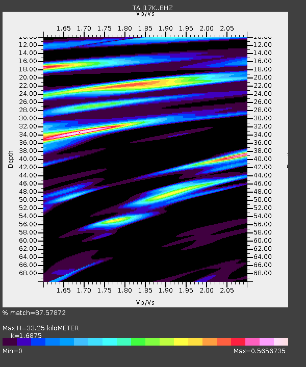
| Estimated Moho Depth: |
33.25 km |
| Estimated Crust Vp/Vs: |
1.69 |
| Assumed Crust Vp: |
6.276 km/s |
| Estimated Crust Vs: |
3.719 km/s |
| Estimated Crust Poisson's Ratio: |
0.23 |
|
| Radial Match: |
87.57872 % |
| Radial Bump: |
400 |
| Transverse Match: |
80.16004 % |
| Transverse Bump: |
400 |
| SOD ConfigId: |
13570011 |
| Insert Time: |
2019-05-01 00:24:49.176 +0000 |
| GWidth: |
2.5 |
| Max Bumps: |
400 |
| Tol: |
0.001 |
|

Signal To Noise
| Channel | StoN | STA | LTA |
| TA:I17K: :BHZ:20180825T22:25:01.125027Z | 4.409638 | 2.203843E-7 | 4.9977867E-8 |
| TA:I17K: :BHN:20180825T22:25:01.125027Z | 1.2847147 | 7.312303E-8 | 5.691772E-8 |
| TA:I17K: :BHE:20180825T22:25:01.125027Z | 1.0191463 | 5.6655264E-8 | 5.5590906E-8 |
| Arrivals |
| Ps | 3.7 SECOND |
| PpPs | 14 SECOND |
| PsPs/PpSs | 18 SECOND |


