You are here: Home > Network List > TA - USArray Transportable Network (new EarthScope stations) Stations List
> Station J14K Nanvaranak Lake, AK, USA > Earthquake Result Viewer
J14K Nanvaranak Lake, AK, USA - Earthquake Result Viewer
| Earthquake location: |
Western Iran |
| Earthquake latitude/longitude: |
34.7/46.2 |
| Earthquake time(UTC): |
2018/08/25 (237) 22:13:26 GMT |
| Earthquake Depth: |
10 km |
| Earthquake Magnitude: |
6.1 Mww |
| Earthquake Catalog/Contributor: |
NEIC PDE/us |
|
| Network: |
TA USArray Transportable Network (new EarthScope stations) |
| Station: |
J14K Nanvaranak Lake, AK, USA |
| Lat/Lon: |
62.75 N/163.55 W |
| Elevation: |
25 m |
|
| Distance: |
80.0 deg |
| Az: |
13.418 deg |
| Baz: |
335.45 deg |
| Ray Param: |
0.04856629 |
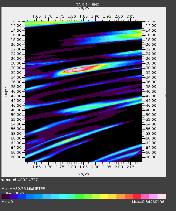
| Estimated Moho Depth: |
30.75 km |
| Estimated Crust Vp/Vs: |
1.80 |
| Assumed Crust Vp: |
6.155 km/s |
| Estimated Crust Vs: |
3.415 km/s |
| Estimated Crust Poisson's Ratio: |
0.28 |
|
| Radial Match: |
90.14777 % |
| Radial Bump: |
400 |
| Transverse Match: |
75.284035 % |
| Transverse Bump: |
400 |
| SOD ConfigId: |
13570011 |
| Insert Time: |
2019-05-01 00:24:53.741 +0000 |
| GWidth: |
2.5 |
| Max Bumps: |
400 |
| Tol: |
0.001 |
|

Signal To Noise
| Channel | StoN | STA | LTA |
| TA:J14K: :BHZ:20180825T22:25:04.000027Z | 2.4437046 | 2.0503394E-7 | 8.390292E-8 |
| TA:J14K: :BHN:20180825T22:25:04.000027Z | 1.3872046 | 1.0854011E-7 | 7.824376E-8 |
| TA:J14K: :BHE:20180825T22:25:04.000027Z | 1.2532661 | 7.6777795E-8 | 6.126216E-8 |
| Arrivals |
| Ps | 4.1 SECOND |
| PpPs | 14 SECOND |
| PsPs/PpSs | 18 SECOND |


