You are here: Home > Network List > TA - USArray Transportable Network (new EarthScope stations) Stations List
> Station L20K Farewell, AK, USA > Earthquake Result Viewer
L20K Farewell, AK, USA - Earthquake Result Viewer
| Earthquake location: |
Western Iran |
| Earthquake latitude/longitude: |
34.7/46.2 |
| Earthquake time(UTC): |
2018/08/25 (237) 22:13:26 GMT |
| Earthquake Depth: |
10 km |
| Earthquake Magnitude: |
6.1 Mww |
| Earthquake Catalog/Contributor: |
NEIC PDE/us |
|
| Network: |
TA USArray Transportable Network (new EarthScope stations) |
| Station: |
L20K Farewell, AK, USA |
| Lat/Lon: |
62.48 N/153.88 W |
| Elevation: |
673 m |
|
| Distance: |
81.8 deg |
| Az: |
9.277 deg |
| Baz: |
343.379 deg |
| Ray Param: |
0.047304336 |
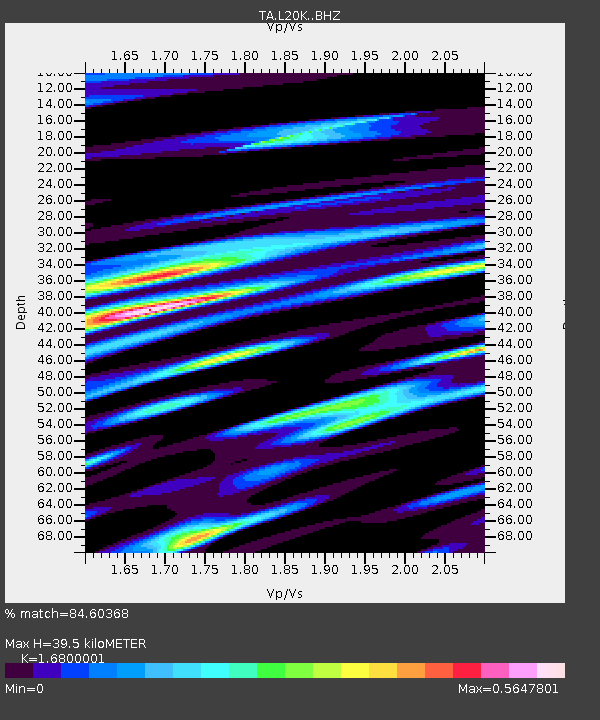
| Estimated Moho Depth: |
39.5 km |
| Estimated Crust Vp/Vs: |
1.68 |
| Assumed Crust Vp: |
6.566 km/s |
| Estimated Crust Vs: |
3.908 km/s |
| Estimated Crust Poisson's Ratio: |
0.23 |
|
| Radial Match: |
84.60368 % |
| Radial Bump: |
400 |
| Transverse Match: |
88.976715 % |
| Transverse Bump: |
400 |
| SOD ConfigId: |
13570011 |
| Insert Time: |
2019-05-01 00:25:02.762 +0000 |
| GWidth: |
2.5 |
| Max Bumps: |
400 |
| Tol: |
0.001 |
|

Signal To Noise
| Channel | StoN | STA | LTA |
| TA:L20K: :BHZ:20180825T22:25:13.725002Z | 3.160693 | 2.2349799E-7 | 7.071171E-8 |
| TA:L20K: :BHN:20180825T22:25:13.725002Z | 1.7332182 | 1.096637E-7 | 6.327172E-8 |
| TA:L20K: :BHE:20180825T22:25:13.725002Z | 1.4190636 | 1.03251374E-7 | 7.2760216E-8 |
| Arrivals |
| Ps | 4.2 SECOND |
| PpPs | 16 SECOND |
| PsPs/PpSs | 20 SECOND |


