You are here: Home > Network List > TA - USArray Transportable Network (new EarthScope stations) Stations List
> Station I23K Minto, Yukon-Koyukuk, AK, USA > Earthquake Result Viewer
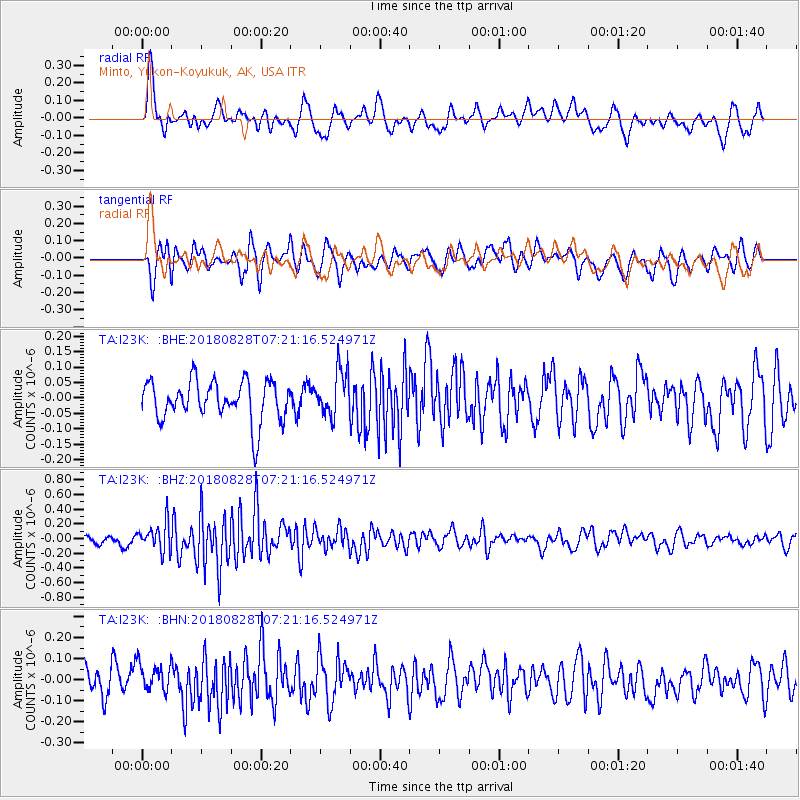
I23K Minto, Yukon-Koyukuk, AK, USA - Earthquake Result Viewer
*The percent match for this event was below the threshold and hence no stack was calculated.
| Earthquake location: |
Timor Region |
| Earthquake latitude/longitude: |
-10.9/124.2 |
| Earthquake time(UTC): |
2018/08/28 (240) 07:08:09 GMT |
| Earthquake Depth: |
8.6 km |
| Earthquake Magnitude: |
6.2 Mww |
| Earthquake Catalog/Contributor: |
NEIC PDE/us |
|
| Network: |
TA USArray Transportable Network (new EarthScope stations) |
| Station: |
I23K Minto, Yukon-Koyukuk, AK, USA |
| Lat/Lon: |
65.15 N/149.36 W |
| Elevation: |
149 m |
|
| Distance: |
98.3 deg |
| Az: |
25.23 deg |
| Baz: |
262.222 deg |
| Ray Param: |
$rayparam |
*The percent match for this event was below the threshold and hence was not used in the summary stack. |
|
| Radial Match: |
62.613293 % |
| Radial Bump: |
400 |
| Transverse Match: |
72.51919 % |
| Transverse Bump: |
400 |
| SOD ConfigId: |
13570011 |
| Insert Time: |
2019-05-01 00:31:46.316 +0000 |
| GWidth: |
2.5 |
| Max Bumps: |
400 |
| Tol: |
0.001 |
|
Signal To Noise
| Channel | StoN | STA | LTA |
| TA:I23K: :BHZ:20180828T07:21:16.524971Z | 3.1834984 | 1.9185299E-7 | 6.026483E-8 |
| TA:I23K: :BHN:20180828T07:21:16.524971Z | 1.2106216 | 6.803626E-8 | 5.6199443E-8 |
| TA:I23K: :BHE:20180828T07:21:16.524971Z | 1.0149872 | 6.599344E-8 | 6.501898E-8 |
| Arrivals |
| Ps | |
| PpPs | |
| PsPs/PpSs | |


