You are here: Home > Network List > AV - Alaska Volcano Observatory Stations List
> Station PLBL Mt. Peulik Volcano, Alaska > Earthquake Result Viewer
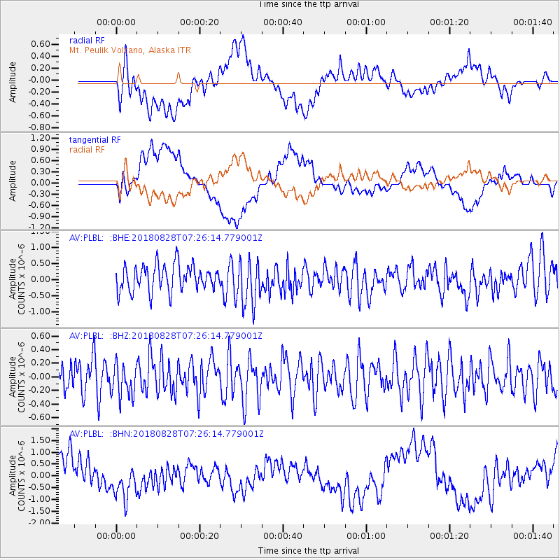
PLBL Mt. Peulik Volcano, Alaska - Earthquake Result Viewer
*The percent match for this event was below the threshold and hence no stack was calculated.
| Earthquake location: |
Timor Region |
| Earthquake latitude/longitude: |
-10.6/124.2 |
| Earthquake time(UTC): |
2018/08/28 (240) 07:13:31 GMT |
| Earthquake Depth: |
10 km |
| Earthquake Magnitude: |
5.6 mb |
| Earthquake Catalog/Contributor: |
NEIC PDE/us |
|
| Network: |
AV Alaska Volcano Observatory |
| Station: |
PLBL Mt. Peulik Volcano, Alaska |
| Lat/Lon: |
57.70 N/156.82 W |
| Elevation: |
461 m |
|
| Distance: |
93.1 deg |
| Az: |
31.863 deg |
| Baz: |
255.141 deg |
| Ray Param: |
$rayparam |
*The percent match for this event was below the threshold and hence was not used in the summary stack. |
|
| Radial Match: |
52.1147 % |
| Radial Bump: |
400 |
| Transverse Match: |
51.2745 % |
| Transverse Bump: |
400 |
| SOD ConfigId: |
13570011 |
| Insert Time: |
2019-05-01 00:33:10.427 +0000 |
| GWidth: |
2.5 |
| Max Bumps: |
400 |
| Tol: |
0.001 |
|
Signal To Noise
| Channel | StoN | STA | LTA |
| AV:PLBL: :BHZ:20180828T07:26:14.779001Z | 1.1239607 | 2.4539276E-7 | 2.1832858E-7 |
| AV:PLBL: :BHN:20180828T07:26:14.779001Z | 1.4893999 | 8.517149E-7 | 5.7185105E-7 |
| AV:PLBL: :BHE:20180828T07:26:14.779001Z | 1.7740583 | 7.193318E-7 | 4.0547246E-7 |
| Arrivals |
| Ps | |
| PpPs | |
| PsPs/PpSs | |


