You are here: Home > Network List > TA - USArray Transportable Network (new EarthScope stations) Stations List
> Station T17A Navajo Res., Navajo Mountain, AZ, USA > Earthquake Result Viewer
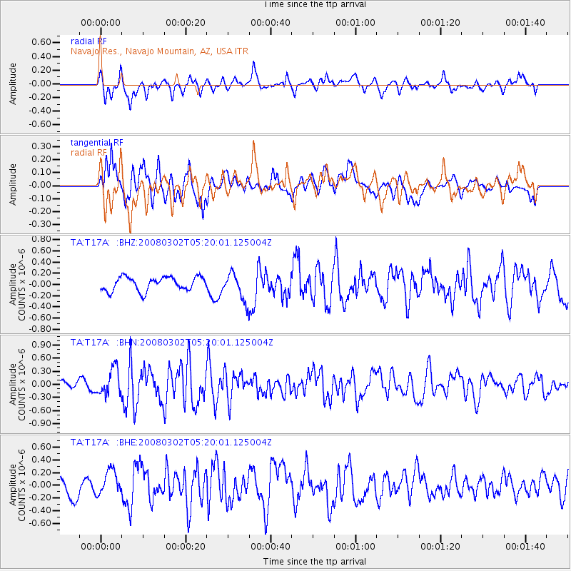
T17A Navajo Res., Navajo Mountain, AZ, USA - Earthquake Result Viewer
*The percent match for this event was below the threshold and hence no stack was calculated.
| Earthquake location: |
Andreanof Islands, Aleutian Is. |
| Earthquake latitude/longitude: |
51.9/-179.3 |
| Earthquake time(UTC): |
2008/03/02 (062) 05:11:44 GMT |
| Earthquake Depth: |
21 km |
| Earthquake Magnitude: |
5.6 MS, 5.4 MB, 5.8 MW, 5.7 MW |
| Earthquake Catalog/Contributor: |
WHDF/NEIC |
|
| Network: |
TA USArray Transportable Network (new EarthScope stations) |
| Station: |
T17A Navajo Res., Navajo Mountain, AZ, USA |
| Lat/Lon: |
37.00 N/110.80 W |
| Elevation: |
1876 m |
|
| Distance: |
49.3 deg |
| Az: |
79.244 deg |
| Baz: |
310.447 deg |
| Ray Param: |
$rayparam |
*The percent match for this event was below the threshold and hence was not used in the summary stack. |
|
| Radial Match: |
61.63912 % |
| Radial Bump: |
400 |
| Transverse Match: |
63.570343 % |
| Transverse Bump: |
400 |
| SOD ConfigId: |
2504 |
| Insert Time: |
2010-03-06 14:52:45.990 +0000 |
| GWidth: |
2.5 |
| Max Bumps: |
400 |
| Tol: |
0.001 |
|
Signal To Noise
| Channel | StoN | STA | LTA |
| TA:T17A: :BHN:20080302T05:20:01.125004Z | 2.286597 | 3.0229327E-7 | 1.3220225E-7 |
| TA:T17A: :BHE:20080302T05:20:01.125004Z | 1.2574521 | 2.3258161E-7 | 1.849626E-7 |
| TA:T17A: :BHZ:20080302T05:20:01.125004Z | 2.0461733 | 2.5000898E-7 | 1.2218369E-7 |
| Arrivals |
| Ps | |
| PpPs | |
| PsPs/PpSs | |


