You are here: Home > Network List > TA - USArray Transportable Network (new EarthScope stations) Stations List
> Station T17A Navajo Res., Navajo Mountain, AZ, USA > Earthquake Result Viewer
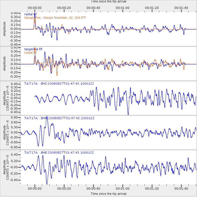
T17A Navajo Res., Navajo Mountain, AZ, USA - Earthquake Result Viewer
*The percent match for this event was below the threshold and hence no stack was calculated.
| Earthquake location: |
Lake Baykal Region, Russia |
| Earthquake latitude/longitude: |
51.6/104.2 |
| Earthquake time(UTC): |
2008/08/27 (240) 01:35:32 GMT |
| Earthquake Depth: |
16 km |
| Earthquake Magnitude: |
5.8 MB, 6.2 MS, 6.2 MW, 6.2 MW |
| Earthquake Catalog/Contributor: |
WHDF/NEIC |
|
| Network: |
TA USArray Transportable Network (new EarthScope stations) |
| Station: |
T17A Navajo Res., Navajo Mountain, AZ, USA |
| Lat/Lon: |
37.00 N/110.80 W |
| Elevation: |
1876 m |
|
| Distance: |
86.6 deg |
| Az: |
27.36 deg |
| Baz: |
339.024 deg |
| Ray Param: |
$rayparam |
*The percent match for this event was below the threshold and hence was not used in the summary stack. |
|
| Radial Match: |
74.33262 % |
| Radial Bump: |
400 |
| Transverse Match: |
72.07589 % |
| Transverse Bump: |
400 |
| SOD ConfigId: |
2504 |
| Insert Time: |
2010-03-06 14:53:01.035 +0000 |
| GWidth: |
2.5 |
| Max Bumps: |
400 |
| Tol: |
0.001 |
|
Signal To Noise
| Channel | StoN | STA | LTA |
| TA:T17A: :BHN:20080827T01:47:43.100012Z | 5.734066 | 3.71898E-7 | 6.4857645E-8 |
| TA:T17A: :BHE:20080827T01:47:43.100012Z | 2.8387241 | 1.7577605E-7 | 6.1920794E-8 |
| TA:T17A: :BHZ:20080827T01:47:43.100012Z | 0.6278379 | 4.5883432E-8 | 7.308165E-8 |
| Arrivals |
| Ps | |
| PpPs | |
| PsPs/PpSs | |


