You are here: Home > Network List > TA - USArray Transportable Network (new EarthScope stations) Stations List
> Station T17A Navajo Res., Navajo Mountain, AZ, USA > Earthquake Result Viewer
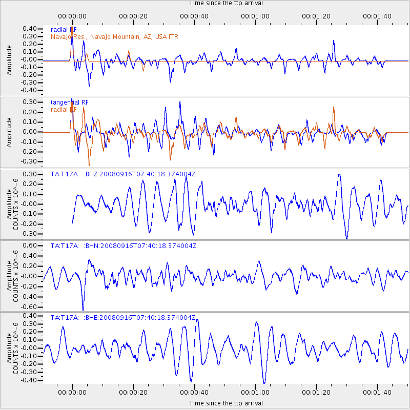
T17A Navajo Res., Navajo Mountain, AZ, USA - Earthquake Result Viewer
*The percent match for this event was below the threshold and hence no stack was calculated.
| Earthquake location: |
Central Mid-Atlantic Ridge |
| Earthquake latitude/longitude: |
0.9/-29.0 |
| Earthquake time(UTC): |
2008/09/16 (260) 07:28:25 GMT |
| Earthquake Depth: |
10 km |
| Earthquake Magnitude: |
5.8 MW, 5.2 MS, 5.2 MB, 5.8 MW |
| Earthquake Catalog/Contributor: |
WHDF/NEIC |
|
| Network: |
TA USArray Transportable Network (new EarthScope stations) |
| Station: |
T17A Navajo Res., Navajo Mountain, AZ, USA |
| Lat/Lon: |
37.00 N/110.80 W |
| Elevation: |
1876 m |
|
| Distance: |
82.9 deg |
| Az: |
307.009 deg |
| Baz: |
94.211 deg |
| Ray Param: |
$rayparam |
*The percent match for this event was below the threshold and hence was not used in the summary stack. |
|
| Radial Match: |
69.25019 % |
| Radial Bump: |
397 |
| Transverse Match: |
62.956844 % |
| Transverse Bump: |
393 |
| SOD ConfigId: |
2560 |
| Insert Time: |
2010-03-06 14:53:10.166 +0000 |
| GWidth: |
2.5 |
| Max Bumps: |
400 |
| Tol: |
0.001 |
|
Signal To Noise
| Channel | StoN | STA | LTA |
| TA:T17A: :BHN:20080916T07:40:18.374004Z | 1.7686174 | 2.2521009E-7 | 1.273368E-7 |
| TA:T17A: :BHE:20080916T07:40:18.374004Z | 0.45772937 | 4.4937565E-8 | 9.8174965E-8 |
| TA:T17A: :BHZ:20080916T07:40:18.374004Z | 1.4274108 | 1.355415E-7 | 9.49562E-8 |
| Arrivals |
| Ps | |
| PpPs | |
| PsPs/PpSs | |


